Belrose geodata
Belrose (New South Wales) is a section of populated place; located in Australia in Australia/Sydney (GMT+11) time zone. With population of 8,714 people, there are 731 cities with bigger population in this country. Compared to other cities in Australia, 50.1% of cities are located further ↓South; 73.5% of cities are located further ←West and 77.8% of cities have lower elevation than Belrose. Note1


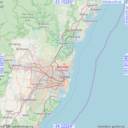
Belrose GPS coordinates[2]
33° 44' 22.344" South, 151° 12' 37.188" East
| Map corner | latitude | longitude |
|---|---|---|
| Upper-left | -33.15285°, | 150.50721° |
| Center: | -33.73954°, | 151.21033° |
| Lower-right: | -34.32224°, | 151.91346° |
| Map W x H: | 130×130 km | = 80.8×80.8mi |
| max Lat: | -10.58257° ⇑49.9% North |
| Belrose: | -33.73954° |
| min Lat: | ⇓50.1% South -43.31423° |
| min Long | Belrose | max Long |
| 113.53327° | 151.21033° | 153.61246° |
| W 73.5%⇐ | ⇒26.5% E |
Elevation
Elevation of Belrose is 154 m = 505 ft, and this is 32 m = 105 ft above average elevation for this country.
| Max E: |
1715 m = 5627 ft | 22.2% |
| Belrose | 154 m 505 ft | |
| Avg. | 122 m = 400 ft | |
Min E: |
-2 m = -7 ft | 77.8% |
See also: Australia elevation on elevation.city.
Geographical zone
Belrose is located in South temperate zone (between Tropic of Capricorn and the Antarctic Circle). Distance of this Southern Tropic circle is 1145.6 km =711.8 mi to North.| Distance of | km | miles | from Belrose |
|---|---|---|---|
| Equator | 3751.5 | 2331.1 | to North |
| Tropic Capricorn | 1145.6 | 711.8 | to North |
| Antarctic Circle | 3649.7 | 2267.8 | to South |
| South Pole | 6255.6 | 3887 | to South |


Nearby cities:
15 places around Belrose: (largest is in red/bold)
• Allambie Heights
4.7 km =2.9 mi,  129°
129°
• Beacon Hill
4.7 km =2.9 mi,  108°
108°
• Castle Cove
5.2 km =3.2 mi,  181°
181°
• Cromer
5.4 km =3.4 mi,  80°
80°
• Davidson
1 km =0.6 mi,  246°
246°
• East Killara
3.2 km =2 mi,  236°
236°
• East Lindfield
3.7 km =2.3 mi,  215°
215°
• Forestville
3 km =1.9 mi, 183°
• Frenchs Forest
1.5 km =0.9 mi, 128°
• Gordon
5.7 km =3.5 mi, 252°
• Killara
5.3 km =3.3 mi, 236°
• Killarney Heights
4 km =2.5 mi,  166°
166°
• Roseville
5.5 km =3.4 mi,  207°
207°
• Roseville Chase
4.5 km =2.8 mi,  196°
196°
• Saint Ives
4.8 km =3 mi,  283°
283°
Sources, notices
• [Note1] Compared only with cities in Australia existing in our database
• [Src1] Map data: © OpenStreetMap contributors (CC-BY-SA)
• [Src2] Other city data from geonames.org with taken over terms of usage.
• [Src3] Geographical zone / Annual Mean Temperature by Robert A. Rohde @ Wikipedia
