Frenchs Forest geodata
Frenchs Forest (New South Wales) is a section of populated place; located in Australia in Australia/Sydney (GMT+11) time zone. With population of 13,278 people, there are 341 cities with bigger population in this country. Compared to other cities in Australia, 50.2% of cities are located further ↑North; 73.9% of cities are located further ←West and 77.6% of cities have lower elevation than Frenchs Forest. Note1


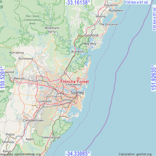
Frenchs Forest GPS coordinates[2]
33° 44' 53.556" South, 151° 13' 23.592" East
| Map corner | latitude | longitude |
|---|---|---|
| Upper-left | -33.16158°, | 150.5201° |
| Center: | -33.74821°, | 151.22322° |
| Lower-right: | -34.33085°, | 151.92635° |
| Map W x H: | 130×130 km | = 80.8×80.8mi |
| max Lat: | -10.58257° ⇑50.2% North |
| Frenchs Forest: | -33.74821° |
| min Lat: | ⇓49.8% South -43.31423° |
| min Long | Frenchs Forest | max Long |
| 113.53327° | 151.22322° | 153.61246° |
| W 73.9%⇐ | ⇒26.1% E |
Elevation
Elevation of Frenchs Forest is 152 m = 499 ft, and this is 30 m = 98 ft above average elevation for this country.
| Max E: |
1715 m = 5627 ft | 22.4% |
| Frenchs Forest | 152 m 499 ft | |
| Avg. | 122 m = 400 ft | |
Min E: |
-2 m = -7 ft | 77.6% |
See also: Australia elevation on elevation.city.
Geographical zone
Frenchs Forest is located in South temperate zone (between Tropic of Capricorn and the Antarctic Circle). Distance of this Southern Tropic circle is 1146.5 km =712.4 mi to North.| Distance of | km | miles | from Frenchs Forest |
|---|---|---|---|
| Equator | 3752.4 | 2331.6 | to North |
| Tropic Capricorn | 1146.5 | 712.4 | to North |
| Antarctic Circle | 3648.7 | 2267.2 | to South |
| South Pole | 6254.6 | 3886.4 | to South |


Nearby cities:
15 places around Frenchs Forest: (largest is in red/bold)
• Allambie Heights
3.2 km =2 mi,  129°
129°
• Beacon Hill
3.3 km =2.1 mi,  98°
98°
• Belrose
1.5 km =0.9 mi,  308°
308°
• Brookvale
4.9 km =3 mi,  106°
106°
• Castle Cove
4.5 km =2.8 mi,  196°
196°
• Cromer
4.5 km =2.8 mi,  65°
65°
• Davidson
2.2 km =1.4 mi,  285°
285°
• East Killara
3.9 km =2.4 mi,  258°
258°
• East Lindfield
3.9 km =2.4 mi,  238°
238°
• Forestville
2.5 km =1.6 mi,  213°
213°
• Killarney Heights
2.9 km =1.8 mi,  185°
185°
• Middle Cove
5.1 km =3.2 mi, 191°
• Narraweena
5 km =3.1 mi, 98°
• North Balgowlah
4.8 km =3 mi,  151°
151°
• Roseville Chase
4.2 km =2.6 mi,  215°
215°
Sources, notices
• [Note1] Compared only with cities in Australia existing in our database
• [Src1] Map data: © OpenStreetMap contributors (CC-BY-SA)
• [Src2] Other city data from geonames.org with taken over terms of usage.
• [Src3] Geographical zone / Annual Mean Temperature by Robert A. Rohde @ Wikipedia
