Bagdad geodata
Bagdad (Tasmania) is a populated place; located in Australia in Australia/Hobart (GMT+11) time zone. With population of 1,337 people, there are 3436 cities with bigger population in this country. Compared to other cities in Australia, 98.2% of cities are located further ↑North; 51.8% of cities are located further →East and 73.9% of cities have lower elevation than Bagdad. Note1


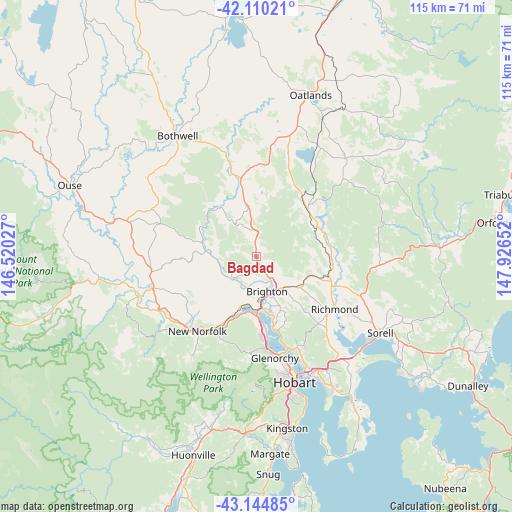
Bagdad GPS coordinates[2]
42° 37' 46.848" South, 147° 13' 24.204" East
| Map corner | latitude | longitude |
|---|---|---|
| Upper-left | -42.11021°, | 146.52027° |
| Center: | -42.62968°, | 147.22339° |
| Lower-right: | -43.14485°, | 147.92652° |
| Map W x H: | 115×115 km | = 71.5×71.5mi |
| max Lat: | -10.58257° ⇑98.2% North |
| Bagdad: | -42.62968° |
| min Lat: | ⇓1.8% South -43.31423° |
| min Long | Bagdad | max Long |
| 113.53327° | 147.22339° | 153.61246° |
| W 48.2%⇐ | ⇒51.8% E |
Elevation
Elevation of Bagdad is 122 m = 400 ft, and this is 0 m = 0 ft above average elevation for this country.
| Max E: |
1715 m = 5627 ft | 26.1% |
| Bagdad | 122 m 400 ft | |
| Avg. | 122 m = 400 ft | |
Min E: |
-2 m = -7 ft | 73.9% |
See also: Australia elevation on elevation.city.
Geographical zone
Bagdad is located in South temperate zone (between Tropic of Capricorn and the Antarctic Circle). Distance of this Southern Tropic circle is 2134.1 km =1326.1 mi to North.| Distance of | km | miles | from Bagdad |
|---|---|---|---|
| Equator | 4740 | 2945.3 | to North |
| Tropic Capricorn | 2134.1 | 1326.1 | to North |
| Antarctic Circle | 2661.2 | 1653.6 | to South |
| South Pole | 5267.1 | 3272.8 | to South |


Nearby cities:
15 places around Bagdad: (largest is in red/bold)
• Austins Ferry
15.4 km =9.6 mi,  171°
171°
• Bridgewater
12 km =7.5 mi,  178°
178°
• Brighton
7.8 km =4.8 mi, 166°
• Campania
16.8 km =10.4 mi,  103°
103°
• Chigwell
20 km =12.4 mi, 174°
• Claremont
17.2 km =10.7 mi, 172°
• Dromedary
12.4 km =7.7 mi,  201°
201°
• Gagebrook
13.7 km =8.5 mi,  163°
163°
• Granton
13.5 km =8.4 mi, 178°
• Herdsmans Cove
13.9 km =8.6 mi, 165°
• Honeywood
11.7 km =7.3 mi, 156°
• Magra
18.5 km =11.5 mi,  223°
223°
• Old Beach
16.8 km =10.4 mi, 167°
• Otago
20.8 km =12.9 mi, 162°
• Pontville
7.4 km =4.6 mi,  149°
149°
Sources, notices
• [Note1] Compared only with cities in Australia existing in our database
• [Src1] Map data: © OpenStreetMap contributors (CC-BY-SA)
• [Src2] Other city data from geonames.org with taken over terms of usage.
• [Src3] Geographical zone / Annual Mean Temperature by Robert A. Rohde @ Wikipedia
