Campania geodata
Campania (Tasmania) is a populated place; located in Australia in Australia/Hobart (GMT+11) time zone. With population of 927 people, there are 3936 cities with bigger population in this country. Compared to other cities in Australia, 98.2% of cities are located further ↑North; 50.1% of cities are located further →East and 64% of cities have lower elevation than Campania. Note1


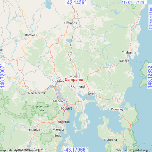
Campania GPS coordinates[2]
42° 39' 53.208" South, 147° 25' 23.484" East
| Map corner | latitude | longitude |
|---|---|---|
| Upper-left | -42.1456°, | 146.72007° |
| Center: | -42.66478°, | 147.42319° |
| Lower-right: | -43.17966°, | 148.12632° |
| Map W x H: | 115×115 km | = 71.5×71.5mi |
| max Lat: | -10.58257° ⇑98.2% North |
| Campania: | -42.66478° |
| min Lat: | ⇓1.8% South -43.31423° |
| min Long | Campania | max Long |
| 113.53327° | 147.42319° | 153.61246° |
| W 49.9%⇐ | ⇒50.1% E |
Elevation
Elevation of Campania is 76 m = 249 ft, and this is 46 m = 151 ft below average elevation for this country.
| Max E: |
1715 m = 5627 ft | 36% |
| Avg. | 122 m = 400 ft | |
| Campania | 76 m = 249 ft | |
Min E: |
-2 m = -7 ft | 64% |
See also: Australia elevation on elevation.city.
Geographical zone
Campania is located in South temperate zone (between Tropic of Capricorn and the Antarctic Circle). Distance of this Southern Tropic circle is 2138 km =1328.5 mi to North.| Distance of | km | miles | from Campania |
|---|---|---|---|
| Equator | 4743.9 | 2947.7 | to North |
| Tropic Capricorn | 2138 | 1328.5 | to North |
| Antarctic Circle | 2657.3 | 1651.2 | to South |
| South Pole | 5263.2 | 3270.4 | to South |


Nearby cities:
15 places around Campania: (largest is in red/bold)
• Austins Ferry
18.1 km =11.2 mi,  231°
231°
• Bagdad
16.8 km =10.4 mi,  283°
283°
• Bridgewater
17.9 km =11.1 mi,  243°
243°
• Brighton
15 km =9.3 mi,  255°
255°
• Cambridge
18.9 km =11.7 mi,  173°
173°
• Gagebrook
15.6 km =9.7 mi, 233°
• Granton
18.6 km =11.6 mi, 238°
• Herdsmans Cove
16.1 km =10 mi, 233°
• Honeywood
13.5 km =8.4 mi, 239°
• Midway Point
16.8 km =10.4 mi,  149°
149°
• Old Beach
17.9 km =11.1 mi, 225°
• Pontville
12.9 km =8 mi, 258°
• Richmond
8 km =5 mi, 171°
• Risdon Vale
17.3 km =10.7 mi,  198°
198°
• Sorell
17.3 km =10.7 mi,  138°
138°
Sources, notices
• [Note1] Compared only with cities in Australia existing in our database
• [Src1] Map data: © OpenStreetMap contributors (CC-BY-SA)
• [Src2] Other city data from geonames.org with taken over terms of usage.
• [Src3] Geographical zone / Annual Mean Temperature by Robert A. Rohde @ Wikipedia
