Mackay geodata
Mackay (Queensland) is a seat of a second-order administrative division; located in Australia in Australia/Brisbane (GMT+10) time zone. With population of 74,219 people, there are 21 cities with bigger population in this country. Compared to other cities in Australia, 93.2% of cities are located further ↓South; 55.2% of cities are located further ←West and 99.1% of cities have higher elevation than Mackay. Note1


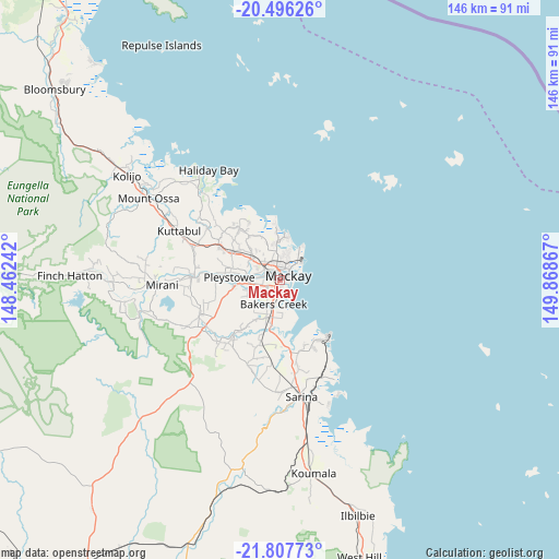
Mackay GPS coordinates[2]
21° 9' 12.42" South, 149° 9' 55.944" East
| Map corner | latitude | longitude |
|---|---|---|
| Upper-left | -20.49626°, | 148.46242° |
| Center: | -21.15345°, | 149.16554° |
| Lower-right: | -21.80773°, | 149.86867° |
| Map W x H: | 145.8×145.8 km | = 90.6×90.6mi |
| max Lat: | -10.58257° ⇑6.8% North |
| Mackay: | -21.15345° |
| min Lat: | ⇓93.2% South -43.31423° |
| min Long | Mackay | max Long |
| 113.53327° | 149.16554° | 153.61246° |
| W 55.2%⇐ | ⇒44.8% E |
Elevation
Elevation of Mackay is 2 m = 7 ft, and this is 120 m = 394 ft below average elevation for this country.
| Max E: |
1715 m = 5627 ft | 99.1% |
| Avg. | 122 m = 400 ft | |
| Mackay | 2 m = 7 ft | |
Min E: |
-2 m = -7 ft | 0.9% |
See also: Mackay elevation on elevation.city.
Geographical zone
Mackay is located in South Torrid zone (between Equator and Tropic of Capricorn). Distance of this Southern Tropic circle is 253.9 km =157.8 mi to South.| Distance of | km | miles | from Mackay |
|---|---|---|---|
| Equator | 2352 | 1461.5 | to North |
| Tropic Capricorn | 253.9 | 157.8 | to South |
| Antarctic Circle | 5049.1 | 3137.4 | to South |
| South Pole | 7655 | 4756.6 | to South |


Nearby cities:
15 places around Mackay: (largest is in red/bold)
• Andergrove
8 km =5 mi,  13°
13°
• Bakers Creek
7.6 km =4.7 mi,  194°
194°
• Beaconsfield
6.9 km =4.3 mi,  359°
359°
• East Mackay
3.2 km =2 mi,  82°
82°
• Erakala
5.8 km =3.6 mi,  299°
299°
• Farleigh
8.4 km =5.2 mi,  309°
309°
• Glenella
4.5 km =2.8 mi,  331°
331°
• Mackay City
2.4 km =1.5 mi,  65°
65°
• Mackay Harbour
6.9 km =4.3 mi,  43°
43°
• Mount Pleasant
4 km =2.5 mi,  351°
351°
• North Mackay
4 km =2.5 mi,  21°
21°
• Ooralea
2.9 km =1.8 mi,  218°
218°
• Rural View
9.9 km =6.2 mi, 359°
• South Mackay
1.6 km =1 mi,  130°
130°
• West Mackay
0.4 km =0.2 mi,  250°
250°
Sources, notices
• [Note1] Compared only with cities in Australia existing in our database
• [Src1] Map data: © OpenStreetMap contributors (CC-BY-SA)
• [Src2] Other city data from geonames.org with taken over terms of usage.
• [Src3] Geographical zone / Annual Mean Temperature by Robert A. Rohde @ Wikipedia
