Kirrawee geodata
Kirrawee (New South Wales) is a section of populated place; located in Australia in Australia/Sydney (GMT+10) time zone. With population of 9,139 people, there are 688 cities with bigger population in this country. Compared to other cities in Australia, 59.8% of cities are located further ↑North; 68.9% of cities are located further ←West and 67.8% of cities have lower elevation than Kirrawee. Note1


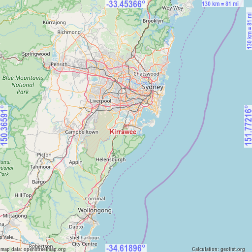
Kirrawee GPS coordinates[2]
34° 2' 17.916" South, 151° 4' 8.508" East
| Map corner | latitude | longitude |
|---|---|---|
| Upper-left | -33.45366°, | 150.36591° |
| Center: | -34.03831°, | 151.06903° |
| Lower-right: | -34.61896°, | 151.77216° |
| Map W x H: | 129.6×129.6 km | = 80.5×80.5mi |
| max Lat: | -10.58257° ⇑59.8% North |
| Kirrawee: | -34.03831° |
| min Lat: | ⇓40.2% South -43.31423° |
| min Long | Kirrawee | max Long |
| 113.53327° | 151.06903° | 153.61246° |
| W 68.9%⇐ | ⇒31.1% E |
Elevation
Elevation of Kirrawee is 92 m = 302 ft, and this is 30 m = 98 ft below average elevation for this country.
| Max E: |
1715 m = 5627 ft | 32.2% |
| Avg. | 122 m = 400 ft | |
| Kirrawee | 92 m = 302 ft | |
Min E: |
-2 m = -7 ft | 67.8% |
See also: Australia elevation on elevation.city.
Geographical zone
Kirrawee is located in South temperate zone (between Tropic of Capricorn and the Antarctic Circle). Distance of this Southern Tropic circle is 1178.8 km =732.5 mi to North.| Distance of | km | miles | from Kirrawee |
|---|---|---|---|
| Equator | 3784.7 | 2351.7 | to North |
| Tropic Capricorn | 1178.8 | 732.5 | to North |
| Antarctic Circle | 3616.5 | 2247.2 | to South |
| South Pole | 6222.4 | 3866.4 | to South |


Nearby cities:
15 places around Kirrawee: (largest is in red/bold)
• Bonnet Bay
3.5 km =2.2 mi,  334°
334°
• Grays Point
2.8 km =1.7 mi,  145°
145°
• Gymea
1.5 km =0.9 mi,  81°
81°
• Gymea Bay
2.3 km =1.4 mi,  131°
131°
• Jannali
2.6 km =1.6 mi,  342°
342°
• Kareela
3.1 km =1.9 mi,  25°
25°
• Loftus
2.2 km =1.4 mi,  251°
251°
• Miranda
2.9 km =1.8 mi,  90°
90°
• Oyster Bay
3.9 km =2.4 mi,  9°
9°
• Sutherland
1.5 km =0.9 mi,  302°
302°
• Sylvania
3.9 km =2.4 mi,  42°
42°
• Woronora
3.2 km =2 mi, 298°
• Woronora Heights
3.9 km =2.4 mi,  274°
274°
• Yarrawarrah
3.5 km =2.2 mi,  241°
241°
• Yowie Bay
3.4 km =2.1 mi,  115°
115°
Sources, notices
• [Note1] Compared only with cities in Australia existing in our database
• [Src1] Map data: © OpenStreetMap contributors (CC-BY-SA)
• [Src2] Other city data from geonames.org with taken over terms of usage.
• [Src3] Geographical zone / Annual Mean Temperature by Robert A. Rohde @ Wikipedia
