Sylvania geodata
Sylvania (New South Wales) is a section of populated place; located in Australia in Australia/Sydney (GMT+10) time zone. With population of 10,422 people, there are 549 cities with bigger population in this country. Compared to other cities in Australia, 59.2% of cities are located further ↑North; 69.8% of cities are located further ←West and 57.6% of cities have higher elevation than Sylvania. Note1


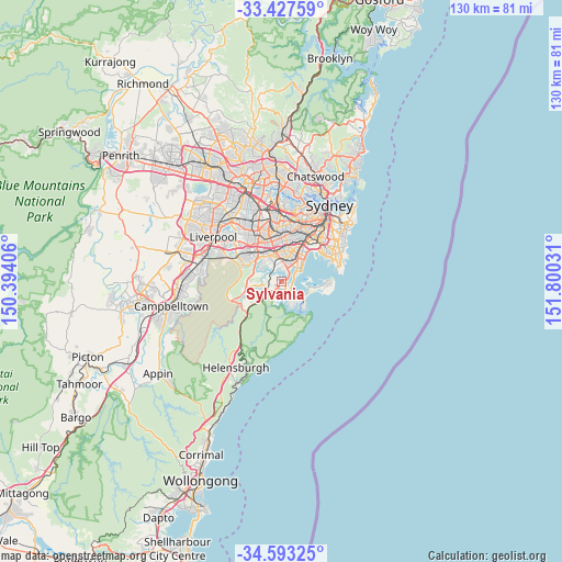
Sylvania GPS coordinates[2]
34° 0' 44.712" South, 151° 5' 49.848" East
| Map corner | latitude | longitude |
|---|---|---|
| Upper-left | -33.42759°, | 150.39406° |
| Center: | -34.01242°, | 151.09718° |
| Lower-right: | -34.59325°, | 151.80031° |
| Map W x H: | 129.6×129.6 km | = 80.5×80.5mi |
| max Lat: | -10.58257° ⇑59.2% North |
| Sylvania: | -34.01242° |
| min Lat: | ⇓40.8% South -43.31423° |
| min Long | Sylvania | max Long |
| 113.53327° | 151.09718° | 153.61246° |
| W 69.8%⇐ | ⇒30.2% E |
Elevation
Elevation of Sylvania is 35 m = 115 ft, and this is 87 m = 285 ft below average elevation for this country.
| Max E: |
1715 m = 5627 ft | 57.6% |
| Avg. | 122 m = 400 ft | |
| Sylvania | 35 m = 115 ft | |
Min E: |
-2 m = -7 ft | 42.4% |
See also: Australia elevation on elevation.city.
Geographical zone
Sylvania is located in South temperate zone (between Tropic of Capricorn and the Antarctic Circle). Distance of this Southern Tropic circle is 1175.9 km =730.7 mi to North.| Distance of | km | miles | from Sylvania |
|---|---|---|---|
| Equator | 3781.8 | 2349.9 | to North |
| Tropic Capricorn | 1175.9 | 730.7 | to North |
| Antarctic Circle | 3619.3 | 2248.9 | to South |
| South Pole | 6225.2 | 3868.2 | to South |


Nearby cities:
15 places around Sylvania: (largest is in red/bold)
• Blakehurst
2.6 km =1.6 mi,  24°
24°
• Caringbah
3.6 km =2.2 mi,  135°
135°
• Carss Park
3.4 km =2.1 mi,  32°
32°
• Como
3.4 km =2.1 mi,  295°
295°
• Connells Point
2.7 km =1.7 mi,  347°
347°
• Gymea
2.9 km =1.8 mi,  202°
202°
• Hurstville Grove
3.7 km =2.3 mi, 350°
• Jannali
3.4 km =2.1 mi,  262°
262°
• Kangaroo Point
1.1 km =0.7 mi, 353°
• Kareela
1.3 km =0.8 mi,  265°
265°
• Kyle Bay
2.7 km =1.7 mi,  4°
4°
• Miranda
2.9 km =1.8 mi,  174°
174°
• Oyster Bay
2.2 km =1.4 mi, 295°
• Sylvania Waters
1.3 km =0.8 mi,  123°
123°
• Taren Point
2.1 km =1.3 mi,  111°
111°
Sources, notices
• [Note1] Compared only with cities in Australia existing in our database
• [Src1] Map data: © OpenStreetMap contributors (CC-BY-SA)
• [Src2] Other city data from geonames.org with taken over terms of usage.
• [Src3] Geographical zone / Annual Mean Temperature by Robert A. Rohde @ Wikipedia
