Blakehurst geodata
Blakehurst (New South Wales) is a section of populated place; located in Australia in Australia/Sydney (GMT+10) time zone. With population of 6,141 people, there are 1173 cities with bigger population in this country. Compared to other cities in Australia, 58.9% of cities are located further ↑North; 70.2% of cities are located further ←West and 50.2% of cities have lower elevation than Blakehurst. Note1


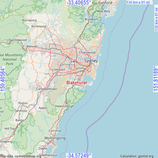
Blakehurst GPS coordinates[2]
33° 59' 29.472" South, 151° 6' 31.536" East
| Map corner | latitude | longitude |
|---|---|---|
| Upper-left | -33.40655°, | 150.40564° |
| Center: | -33.99152°, | 151.10876° |
| Lower-right: | -34.57249°, | 151.81189° |
| Map W x H: | 129.6×129.6 km | = 80.5×80.5mi |
| max Lat: | -10.58257° ⇑58.9% North |
| Blakehurst: | -33.99152° |
| min Lat: | ⇓41.1% South -43.31423° |
| min Long | Blakehurst | max Long |
| 113.53327° | 151.10876° | 153.61246° |
| W 70.2%⇐ | ⇒29.8% E |
Elevation
Elevation of Blakehurst is 46 m = 151 ft, and this is 76 m = 249 ft below average elevation for this country.
| Max E: |
1715 m = 5627 ft | 49.8% |
| Avg. | 122 m = 400 ft | |
| Blakehurst | 46 m = 151 ft | |
Min E: |
-2 m = -7 ft | 50.2% |
See also: Australia elevation on elevation.city.
Geographical zone
Blakehurst is located in South temperate zone (between Tropic of Capricorn and the Antarctic Circle). Distance of this Southern Tropic circle is 1173.6 km =729.2 mi to North.| Distance of | km | miles | from Blakehurst |
|---|---|---|---|
| Equator | 3779.5 | 2348.5 | to North |
| Tropic Capricorn | 1173.6 | 729.2 | to North |
| Antarctic Circle | 3621.7 | 2250.4 | to South |
| South Pole | 6227.6 | 3869.7 | to South |


Nearby cities:
15 places around Blakehurst: (largest is in red/bold)
• Allawah
2.2 km =1.4 mi,  13°
13°
• Beverley Park
2.9 km =1.8 mi,  55°
55°
• Carlton
2.6 km =1.6 mi,  27°
27°
• Carss Park
1 km =0.6 mi, 55°
• Connells Point
1.7 km =1.1 mi,  282°
282°
• Hurstville
2.7 km =1.7 mi,  345°
345°
• Hurstville Grove
2.1 km =1.3 mi,  307°
307°
• Kangaroo Point
1.7 km =1.1 mi,  223°
223°
• Kogarah Bay
1.8 km =1.1 mi,  40°
40°
• Kyle Bay
1 km =0.6 mi,  295°
295°
• Sandringham
2.8 km =1.7 mi,  96°
96°
• Sans Souci
2.3 km =1.4 mi,  85°
85°
• South Hurstville
1.6 km =1 mi, 349°
• Sylvania
2.6 km =1.6 mi,  204°
204°
• Sylvania Waters
3 km =1.9 mi,  180°
180°
Sources, notices
• [Note1] Compared only with cities in Australia existing in our database
• [Src1] Map data: © OpenStreetMap contributors (CC-BY-SA)
• [Src2] Other city data from geonames.org with taken over terms of usage.
• [Src3] Geographical zone / Annual Mean Temperature by Robert A. Rohde @ Wikipedia
