Illawong geodata
Illawong (New South Wales) is a section of populated place; located in Australia in Australia/Sydney (GMT+10) time zone. With population of 7,206 people, there are 946 cities with bigger population in this country. Compared to other cities in Australia, 59.1% of cities are located further ↑North; 68.1% of cities are located further ←West and 69.5% of cities have lower elevation than Illawong. Note1


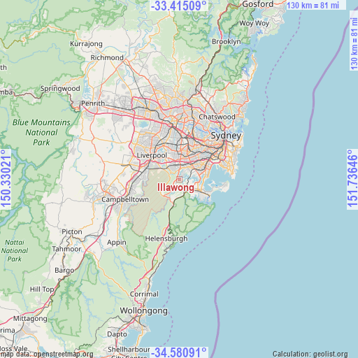
Illawong GPS coordinates[2]
34° 0' 0" South, 151° 1' 59.988" East
| Map corner | latitude | longitude |
|---|---|---|
| Upper-left | -33.41509°, | 150.33021° |
| Center: | -34°, | 151.03333° |
| Lower-right: | -34.58091°, | 151.73646° |
| Map W x H: | 129.6×129.6 km | = 80.5×80.5mi |
| max Lat: | -10.58257° ⇑59.1% North |
| Illawong: | -34° |
| min Lat: | ⇓40.9% South -43.31423° |
| min Long | Illawong | max Long |
| 113.53327° | 151.03333° | 153.61246° |
| W 68.1%⇐ | ⇒31.9% E |
Elevation
Elevation of Illawong is 100 m = 328 ft, and this is 22 m = 72 ft below average elevation for this country.
| Max E: |
1715 m = 5627 ft | 30.5% |
| Avg. | 122 m = 400 ft | |
| Illawong | 100 m = 328 ft | |
Min E: |
-2 m = -7 ft | 69.5% |
See also: Australia elevation on elevation.city.
Geographical zone
Illawong is located in South temperate zone (between Tropic of Capricorn and the Antarctic Circle). Distance of this Southern Tropic circle is 1174.5 km =729.8 mi to North.| Distance of | km | miles | from Illawong |
|---|---|---|---|
| Equator | 3780.4 | 2349 | to North |
| Tropic Capricorn | 1174.5 | 729.8 | to North |
| Antarctic Circle | 3620.7 | 2249.8 | to South |
| South Pole | 6226.6 | 3869 | to South |


Nearby cities:
15 places around Illawong: (largest is in red/bold)
• Alfords Point
1.6 km =1 mi,  331°
331°
• Bangor
1.9 km =1.2 mi,  180°
180°
• Bonnet Bay
2.1 km =1.3 mi,  122°
122°
• Como
2.8 km =1.7 mi,  88°
88°
• Jannali
3.1 km =1.9 mi,  125°
125°
• Lugarno
2.1 km =1.3 mi,  22°
22°
• Menai
2.4 km =1.5 mi,  219°
219°
• Oyster Bay
3.9 km =2.4 mi,  96°
96°
• Padstow Heights
3.7 km =2.3 mi,  9°
9°
• Peakhurst Heights
3.2 km =2 mi,  39°
39°
• Picnic Point
4 km =2.5 mi,  302°
302°
• Revesby Heights
3.9 km =2.4 mi,  339°
339°
• Sutherland
4 km =2.5 mi,  149°
149°
• Woronora
2.8 km =1.7 mi,  169°
169°
• Woronora Heights
4 km =2.5 mi,  187°
187°
Sources, notices
• [Note1] Compared only with cities in Australia existing in our database
• [Src1] Map data: © OpenStreetMap contributors (CC-BY-SA)
• [Src2] Other city data from geonames.org with taken over terms of usage.
• [Src3] Geographical zone / Annual Mean Temperature by Robert A. Rohde @ Wikipedia
