Lugarno geodata
Lugarno (New South Wales) is a section of populated place; located in Australia in Australia/Sydney (GMT+10) time zone. With population of 5,521 people, there are 1341 cities with bigger population in this country. Compared to other cities in Australia, 58.7% of cities are located further ↑North; 68.4% of cities are located further ←West and 55.8% of cities have lower elevation than Lugarno. Note1


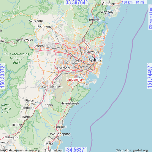
Lugarno GPS coordinates[2]
33° 58' 57.612" South, 151° 2' 30.624" East
| Map corner | latitude | longitude |
|---|---|---|
| Upper-left | -33.39764°, | 150.33872° |
| Center: | -33.98267°, | 151.04184° |
| Lower-right: | -34.5637°, | 151.74497° |
| Map W x H: | 129.7×129.7 km | = 80.6×80.6mi |
| max Lat: | -10.58257° ⇑58.7% North |
| Lugarno: | -33.98267° |
| min Lat: | ⇓41.3% South -43.31423° |
| min Long | Lugarno | max Long |
| 113.53327° | 151.04184° | 153.61246° |
| W 68.4%⇐ | ⇒31.6% E |
Elevation
Elevation of Lugarno is 55 m = 180 ft, and this is 67 m = 220 ft below average elevation for this country.
| Max E: |
1715 m = 5627 ft | 44.2% |
| Avg. | 122 m = 400 ft | |
| Lugarno | 55 m = 180 ft | |
Min E: |
-2 m = -7 ft | 55.8% |
See also: Australia elevation on elevation.city.
Geographical zone
Lugarno is located in South temperate zone (between Tropic of Capricorn and the Antarctic Circle). Distance of this Southern Tropic circle is 1172.6 km =728.6 mi to North.| Distance of | km | miles | from Lugarno |
|---|---|---|---|
| Equator | 3778.5 | 2347.9 | to North |
| Tropic Capricorn | 1172.6 | 728.6 | to North |
| Antarctic Circle | 3622.7 | 2251 | to South |
| South Pole | 6228.5 | 3870.2 | to South |


Nearby cities:
15 places around Lugarno: (largest is in red/bold)
• Alfords Point
1.6 km =1 mi,  250°
250°
• Bangor
3.9 km =2.4 mi,  191°
191°
• Bonnet Bay
3.2 km =2 mi,  162°
162°
• Como
2.8 km =1.7 mi,  132°
132°
• Illawong
2.1 km =1.3 mi,  202°
202°
• Jannali
4.1 km =2.5 mi, 155°
• Mortdale
3.2 km =2 mi,  61°
61°
• Oatley
2.8 km =1.7 mi,  83°
83°
• Oyster Bay
3.9 km =2.4 mi, 127°
• Padstow
3 km =1.9 mi,  342°
342°
• Padstow Heights
1.7 km =1.1 mi,  354°
354°
• Peakhurst
2.4 km =1.5 mi,  22°
22°
• Peakhurst Heights
1.4 km =0.9 mi, 64°
• Revesby Heights
2.8 km =1.7 mi,  308°
308°
• Riverwood
4 km =2.5 mi,  10°
10°
Sources, notices
• [Note1] Compared only with cities in Australia existing in our database
• [Src1] Map data: © OpenStreetMap contributors (CC-BY-SA)
• [Src2] Other city data from geonames.org with taken over terms of usage.
• [Src3] Geographical zone / Annual Mean Temperature by Robert A. Rohde @ Wikipedia
