Palm Cove geodata
Palm Cove (Queensland) is a section of populated place; located in Australia in Australia/Brisbane (GMT+10) time zone. With population of 3,713 people, there are 1911 cities with bigger population in this country. Compared to other cities in Australia, 97.7% of cities are located further ↓South; 58.8% of cities are located further →East and 72.3% of cities have higher elevation than Palm Cove. Note1


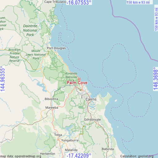
Palm Cove GPS coordinates[2]
16° 45' 0" South, 145° 40' 0.012" East
| Map corner | latitude | longitude |
|---|---|---|
| Upper-left | -16.07553°, | 144.96355° |
| Center: | -16.75°, | 145.66667° |
| Lower-right: | -17.42209°, | 146.3698° |
| Map W x H: | 149.7×149.7 km | = 93×93mi |
| max Lat: | -10.58257° ⇑2.3% North |
| Palm Cove: | -16.75° |
| min Lat: | ⇓97.7% South -43.31423° |
| min Long | Palm Cove | max Long |
| 113.53327° | 145.66667° | 153.61246° |
| W 41.2%⇐ | ⇒58.8% E |
Elevation
Elevation of Palm Cove is 21 m = 69 ft, and this is 101 m = 331 ft below average elevation for this country.
| Max E: |
1715 m = 5627 ft | 72.3% |
| Avg. | 122 m = 400 ft | |
| Palm Cove | 21 m = 69 ft | |
Min E: |
-2 m = -7 ft | 27.7% |
See also: Australia elevation on elevation.city.
Geographical zone
Palm Cove is located in South Torrid zone (between Equator and Tropic of Capricorn). Distance of this Southern Tropic circle is 743.5 km =462 mi to South.| Distance of | km | miles | from Palm Cove |
|---|---|---|---|
| Equator | 1862.4 | 1157.2 | to North |
| Tropic Capricorn | 743.5 | 462 | to South |
| Antarctic Circle | 5538.7 | 3441.6 | to South |
| South Pole | 8144.6 | 5060.8 | to South |


Nearby cities:
15 places around Palm Cove: (largest is in red/bold)
• Brinsmead
17.4 km =10.8 mi,  162°
162°
• Caravonica
13.5 km =8.4 mi,  173°
173°
• Clifton Beach
1.6 km =1 mi, 159°
• Edge Hill
18.9 km =11.7 mi,  151°
151°
• Freshwater
15.8 km =9.8 mi, 160°
• Holloways Beach
12.8 km =8 mi,  142°
142°
• Kamerunga
14.2 km =8.8 mi, 164°
• Kewarra Beach
4.1 km =2.5 mi, 151°
• Kuranda
8.3 km =5.2 mi,  201°
201°
• Machans Beach
14.6 km =9.1 mi, 145°
• Speewah
16.5 km =10.3 mi, 200°
• Trinity Beach
5.4 km =3.4 mi, 143°
• Trinity Park
7.6 km =4.7 mi, 146°
• Whitfield
17.6 km =10.9 mi, 156°
• Yorkeys Knob
8.2 km =5.1 mi, 135°
Sources, notices
• [Note1] Compared only with cities in Australia existing in our database
• [Src1] Map data: © OpenStreetMap contributors (CC-BY-SA)
• [Src2] Other city data from geonames.org with taken over terms of usage.
• [Src3] Geographical zone / Annual Mean Temperature by Robert A. Rohde @ Wikipedia
