Kamerunga geodata
Kamerunga (Queensland) is a section of populated place; located in Australia in Australia/Brisbane (GMT+10) time zone. With population of 1,026 people, there are 3788 cities with bigger population in this country. Compared to other cities in Australia, 97.5% of cities are located further ↓South; 58.6% of cities are located further →East and 93.8% of cities have higher elevation than Kamerunga. Note1


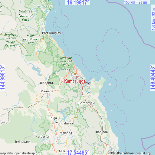
Kamerunga GPS coordinates[2]
16° 52' 23.556" South, 145° 42' 4.68" East
| Map corner | latitude | longitude |
|---|---|---|
| Upper-left | -16.19917°, | 144.99818° |
| Center: | -16.87321°, | 145.7013° |
| Lower-right: | -17.54485°, | 146.40443° |
| Map W x H: | 149.6×149.6 km | = 93×93mi |
| max Lat: | -10.58257° ⇑2.5% North |
| Kamerunga: | -16.87321° |
| min Lat: | ⇓97.5% South -43.31423° |
| min Long | Kamerunga | max Long |
| 113.53327° | 145.7013° | 153.61246° |
| W 41.4%⇐ | ⇒58.6% E |
Elevation
Elevation of Kamerunga is 7 m = 23 ft, and this is 115 m = 377 ft below average elevation for this country.
| Max E: |
1715 m = 5627 ft | 93.8% |
| Avg. | 122 m = 400 ft | |
| Kamerunga | 7 m = 23 ft | |
Min E: |
-2 m = -7 ft | 6.2% |
See also: Australia elevation on elevation.city.
Geographical zone
Kamerunga is located in South Torrid zone (between Equator and Tropic of Capricorn). Distance of this Southern Tropic circle is 729.8 km =453.5 mi to South.| Distance of | km | miles | from Kamerunga |
|---|---|---|---|
| Equator | 1876.1 | 1165.8 | to North |
| Tropic Capricorn | 729.8 | 453.5 | to South |
| Antarctic Circle | 5525 | 3433.1 | to South |
| South Pole | 8130.9 | 5052.3 | to South |


Nearby cities:
15 places around Kamerunga: (largest is in red/bold)
• Brinsmead
3.3 km =2.1 mi,  152°
152°
• Cairns North
6.9 km =4.3 mi,  120°
120°
• Caravonica
2.2 km =1.4 mi,  277°
277°
• Edge Hill
6 km =3.7 mi, 119°
• Freshwater
2 km =1.2 mi, 124°
• Holloways Beach
5.3 km =3.3 mi,  49°
49°
• Kanimbla
5.9 km =3.7 mi,  158°
158°
• Machans Beach
4.9 km =3 mi,  70°
70°
• Manoora
6.2 km =3.9 mi,  142°
142°
• Manunda
7.1 km =4.4 mi,  133°
133°
• Mooroobool
7.6 km =4.7 mi, 154°
• Redlynch
5.8 km =3.6 mi,  185°
185°
• Trinity Park
7.4 km =4.6 mi,  3°
3°
• Whitfield
4.2 km =2.6 mi, 125°
• Yorkeys Knob
8.1 km =5 mi,  14°
14°
Sources, notices
• [Note1] Compared only with cities in Australia existing in our database
• [Src1] Map data: © OpenStreetMap contributors (CC-BY-SA)
• [Src2] Other city data from geonames.org with taken over terms of usage.
• [Src3] Geographical zone / Annual Mean Temperature by Robert A. Rohde @ Wikipedia
