Arncliffe geodata
Arncliffe (New South Wales) is a section of populated place; located in Australia in Australia/Sydney (GMT+11) time zone. With population of 10,523 people, there are 538 cities with bigger population in this country. Compared to other cities in Australia, 57.4% of cities are located further ↑North; 71.7% of cities are located further ←West and 74.7% of cities have higher elevation than Arncliffe. Note1


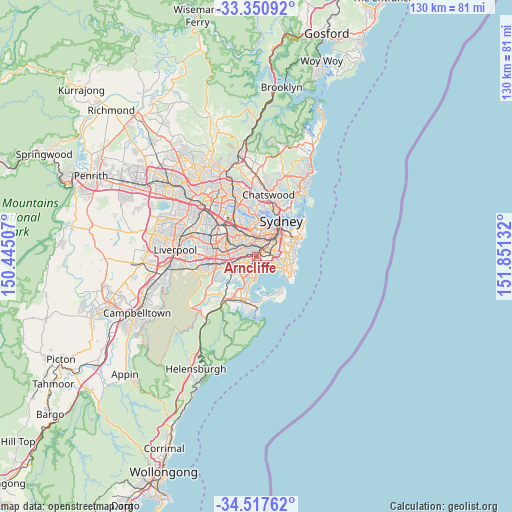
Arncliffe GPS coordinates[2]
33° 56' 10.572" South, 151° 8' 53.484" East
| Map corner | latitude | longitude |
|---|---|---|
| Upper-left | -33.35092°, | 150.44507° |
| Center: | -33.93627°, | 151.14819° |
| Lower-right: | -34.51762°, | 151.85132° |
| Map W x H: | 129.7×129.7 km | = 80.6×80.6mi |
| max Lat: | -10.58257° ⇑57.4% North |
| Arncliffe: | -33.93627° |
| min Lat: | ⇓42.6% South -43.31423° |
| min Long | Arncliffe | max Long |
| 113.53327° | 151.14819° | 153.61246° |
| W 71.7%⇐ | ⇒28.3% E |
Elevation
Elevation of Arncliffe is 19 m = 62 ft, and this is 103 m = 338 ft below average elevation for this country.
| Max E: |
1715 m = 5627 ft | 74.7% |
| Avg. | 122 m = 400 ft | |
| Arncliffe | 19 m = 62 ft | |
Min E: |
-2 m = -7 ft | 25.3% |
See also: Australia elevation on elevation.city.
Geographical zone
Arncliffe is located in South temperate zone (between Tropic of Capricorn and the Antarctic Circle). Distance of this Southern Tropic circle is 1167.4 km =725.4 mi to North.| Distance of | km | miles | from Arncliffe |
|---|---|---|---|
| Equator | 3773.4 | 2344.7 | to North |
| Tropic Capricorn | 1167.4 | 725.4 | to North |
| Antarctic Circle | 3627.8 | 2254.2 | to South |
| South Pole | 6233.7 | 3873.4 | to South |


Nearby cities:
15 places around Arncliffe: (largest is in red/bold)
• Banksia
1.2 km =0.7 mi,  203°
203°
• Bardwell Park
2.1 km =1.3 mi,  272°
272°
• Bardwell Valley
1.1 km =0.7 mi,  286°
286°
• Bexley
3.3 km =2.1 mi,  242°
242°
• Bexley North
3.2 km =2 mi, 265°
• Brighton-Le-Sands
2.7 km =1.7 mi,  174°
174°
• Earlwood
2.7 km =1.7 mi,  308°
308°
• Hurlstone Park
3.4 km =2.1 mi,  328°
328°
• Kyeemagh
2.1 km =1.3 mi,  142°
142°
• Marrickville
3.3 km =2.1 mi,  11°
11°
• Rockdale
2.1 km =1.3 mi,  221°
221°
• Sydenham
2.8 km =1.7 mi,  39°
39°
• Tempe
1.8 km =1.1 mi, 37°
• Turrella
0.9 km =0.6 mi,  319°
319°
• Wolli Creek
0.7 km =0.4 mi,  34°
34°
Sources, notices
• [Note1] Compared only with cities in Australia existing in our database
• [Src1] Map data: © OpenStreetMap contributors (CC-BY-SA)
• [Src2] Other city data from geonames.org with taken over terms of usage.
• [Src3] Geographical zone / Annual Mean Temperature by Robert A. Rohde @ Wikipedia
