Turrella geodata
Turrella (New South Wales) is a section of populated place; located in Australia in Australia/Sydney (GMT+11) time zone. With population of 2,496 people, there are 2574 cities with bigger population in this country. Compared to other cities in Australia, 57.1% of cities are located further ↑North; 71.5% of cities are located further ←West and 86.8% of cities have higher elevation than Turrella. Note1


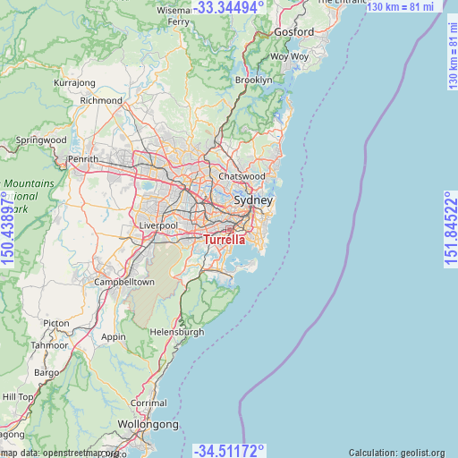
Turrella GPS coordinates[2]
33° 55' 49.188" South, 151° 8' 31.524" East
| Map corner | latitude | longitude |
|---|---|---|
| Upper-left | -33.34494°, | 150.43897° |
| Center: | -33.93033°, | 151.14209° |
| Lower-right: | -34.51172°, | 151.84522° |
| Map W x H: | 129.7×129.7 km | = 80.6×80.6mi |
| max Lat: | -10.58257° ⇑57.1% North |
| Turrella: | -33.93033° |
| min Lat: | ⇓42.9% South -43.31423° |
| min Long | Turrella | max Long |
| 113.53327° | 151.14209° | 153.61246° |
| W 71.5%⇐ | ⇒28.5% E |
Elevation
Elevation of Turrella is 11 m = 36 ft, and this is 111 m = 364 ft below average elevation for this country.
| Max E: |
1715 m = 5627 ft | 86.8% |
| Avg. | 122 m = 400 ft | |
| Turrella | 11 m = 36 ft | |
Min E: |
-2 m = -7 ft | 13.2% |
See also: Australia elevation on elevation.city.
Geographical zone
Turrella is located in South temperate zone (between Tropic of Capricorn and the Antarctic Circle). Distance of this Southern Tropic circle is 1166.8 km =725 mi to North.| Distance of | km | miles | from Turrella |
|---|---|---|---|
| Equator | 3772.7 | 2344.2 | to North |
| Tropic Capricorn | 1166.8 | 725 | to North |
| Antarctic Circle | 3628.5 | 2254.6 | to South |
| South Pole | 6234.4 | 3873.9 | to South |


Nearby cities:
15 places around Turrella: (largest is in red/bold)
• Arncliffe
0.9 km =0.6 mi,  139°
139°
• Banksia
1.7 km =1.1 mi,  177°
177°
• Bardwell Park
1.6 km =1 mi,  249°
249°
• Bardwell Valley
0.6 km =0.4 mi,  235°
235°
• Bexley North
2.8 km =1.7 mi, 250°
• Canterbury
3 km =1.9 mi,  313°
313°
• Dulwich Hill
2.9 km =1.8 mi,  355°
355°
• Earlwood
1.9 km =1.2 mi,  303°
303°
• Hurlstone Park
2.6 km =1.6 mi,  331°
331°
• Kyeemagh
3 km =1.9 mi, 141°
• Marrickville
2.8 km =1.7 mi,  25°
25°
• Rockdale
2.3 km =1.4 mi,  200°
200°
• Sydenham
2.8 km =1.7 mi,  57°
57°
• Tempe
1.8 km =1.1 mi,  65°
65°
• Wolli Creek
0.9 km =0.6 mi,  96°
96°
Sources, notices
• [Note1] Compared only with cities in Australia existing in our database
• [Src1] Map data: © OpenStreetMap contributors (CC-BY-SA)
• [Src2] Other city data from geonames.org with taken over terms of usage.
• [Src3] Geographical zone / Annual Mean Temperature by Robert A. Rohde @ Wikipedia
