Banksia geodata
Banksia (New South Wales) is a section of populated place; located in Australia in Australia/Sydney (GMT+11) time zone. With population of 3,342 people, there are 2051 cities with bigger population in this country. Compared to other cities in Australia, 57.6% of cities are located further ↑North; 71.5% of cities are located further ←West and 80.4% of cities have higher elevation than Banksia. Note1


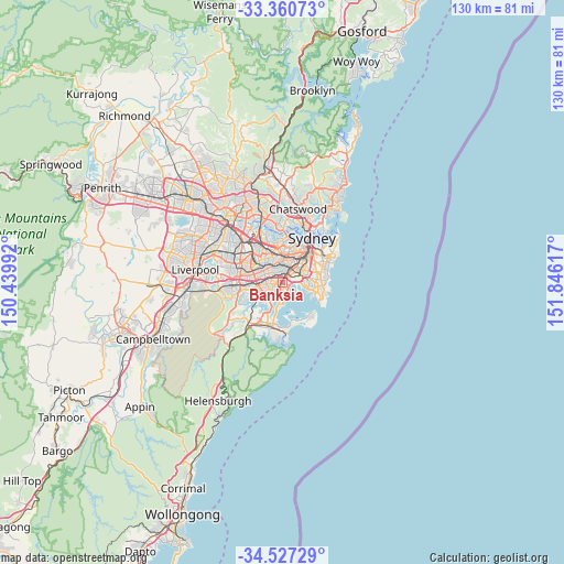
Banksia GPS coordinates[2]
33° 56' 45.636" South, 151° 8' 34.944" East
| Map corner | latitude | longitude |
|---|---|---|
| Upper-left | -33.36073°, | 150.43992° |
| Center: | -33.94601°, | 151.14304° |
| Lower-right: | -34.52729°, | 151.84617° |
| Map W x H: | 129.7×129.7 km | = 80.6×80.6mi |
| max Lat: | -10.58257° ⇑57.6% North |
| Banksia: | -33.94601° |
| min Lat: | ⇓42.4% South -43.31423° |
| min Long | Banksia | max Long |
| 113.53327° | 151.14304° | 153.61246° |
| W 71.5%⇐ | ⇒28.5% E |
Elevation
Elevation of Banksia is 15 m = 49 ft, and this is 107 m = 351 ft below average elevation for this country.
| Max E: |
1715 m = 5627 ft | 80.4% |
| Avg. | 122 m = 400 ft | |
| Banksia | 15 m = 49 ft | |
Min E: |
-2 m = -7 ft | 19.6% |
See also: Australia elevation on elevation.city.
Geographical zone
Banksia is located in South temperate zone (between Tropic of Capricorn and the Antarctic Circle). Distance of this Southern Tropic circle is 1168.5 km =726.1 mi to North.| Distance of | km | miles | from Banksia |
|---|---|---|---|
| Equator | 3774.4 | 2345.3 | to North |
| Tropic Capricorn | 1168.5 | 726.1 | to North |
| Antarctic Circle | 3626.7 | 2253.5 | to South |
| South Pole | 6232.6 | 3872.8 | to South |


Nearby cities:
15 places around Banksia: (largest is in red/bold)
• Arncliffe
1.2 km =0.7 mi,  23°
23°
• Bardwell Park
2 km =1.2 mi,  306°
306°
• Bardwell Valley
1.5 km =0.9 mi,  337°
337°
• Bexley
2.5 km =1.6 mi,  259°
259°
• Bexley North
2.8 km =1.7 mi,  287°
287°
• Brighton-Le-Sands
1.7 km =1.1 mi,  154°
154°
• Carlton
3.4 km =2.1 mi,  215°
215°
• Earlwood
3.2 km =2 mi,  329°
329°
• Kogarah
2.5 km =1.6 mi,  195°
195°
• Kyeemagh
1.8 km =1.1 mi,  108°
108°
• Monterey
3 km =1.9 mi,  170°
170°
• Rockdale
1 km =0.6 mi,  243°
243°
• Tempe
3 km =1.9 mi,  32°
32°
• Turrella
1.7 km =1.1 mi,  357°
357°
• Wolli Creek
1.8 km =1.1 mi, 27°
Sources, notices
• [Note1] Compared only with cities in Australia existing in our database
• [Src1] Map data: © OpenStreetMap contributors (CC-BY-SA)
• [Src2] Other city data from geonames.org with taken over terms of usage.
• [Src3] Geographical zone / Annual Mean Temperature by Robert A. Rohde @ Wikipedia
