Willoughby geodata
Willoughby (New South Wales) is a section of populated place; located in Australia in Australia/Sydney (GMT+11) time zone. With population of 6,451 people, there are 1086 cities with bigger population in this country. Compared to other cities in Australia, 52.1% of cities are located further ↑North; 73% of cities are located further ←West and 66.6% of cities have lower elevation than Willoughby. Note1


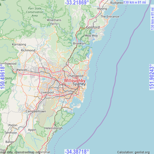
Willoughby GPS coordinates[2]
33° 48' 17.748" South, 151° 11' 57.48" East
| Map corner | latitude | longitude |
|---|---|---|
| Upper-left | -33.21869°, | 150.49618° |
| Center: | -33.80493°, | 151.1993° |
| Lower-right: | -34.38718°, | 151.90243° |
| Map W x H: | 129.9×129.9 km | = 80.7×80.7mi |
| max Lat: | -10.58257° ⇑52.1% North |
| Willoughby: | -33.80493° |
| min Lat: | ⇓47.9% South -43.31423° |
| min Long | Willoughby | max Long |
| 113.53327° | 151.1993° | 153.61246° |
| W 73%⇐ | ⇒27% E |
Elevation
Elevation of Willoughby is 86 m = 282 ft, and this is 36 m = 118 ft below average elevation for this country.
| Max E: |
1715 m = 5627 ft | 33.4% |
| Avg. | 122 m = 400 ft | |
| Willoughby | 86 m = 282 ft | |
Min E: |
-2 m = -7 ft | 66.6% |
See also: Australia elevation on elevation.city.
Geographical zone
Willoughby is located in South temperate zone (between Tropic of Capricorn and the Antarctic Circle). Distance of this Southern Tropic circle is 1152.8 km =716.3 mi to North.| Distance of | km | miles | from Willoughby |
|---|---|---|---|
| Equator | 3758.8 | 2335.6 | to North |
| Tropic Capricorn | 1152.8 | 716.3 | to North |
| Antarctic Circle | 3642.4 | 2263.3 | to South |
| South Pole | 6248.3 | 3882.5 | to South |


Nearby cities:
15 places around Willoughby: (largest is in red/bold)
• Artarmon
2 km =1.2 mi,  228°
228°
• Cammeray
2.4 km =1.5 mi,  139°
139°
• Castle Cove
2.2 km =1.4 mi,  24°
24°
• Castlecrag
2.3 km =1.4 mi,  75°
75°
• Chatswood
1.6 km =1 mi,  290°
290°
• Crows Nest
2.3 km =1.4 mi,  169°
169°
• Lane Cove North
3 km =1.9 mi,  268°
268°
• Middle Cove
1.8 km =1.1 mi,  42°
42°
• Naremburn
1.3 km =0.8 mi, 174°
• North Willoughby
1 km =0.6 mi,  6°
6°
• Northbridge
1.9 km =1.2 mi,  118°
118°
• Roseville
2.8 km =1.7 mi,  328°
328°
• Roseville Chase
2.9 km =1.8 mi,  355°
355°
• St Leonards
2.1 km =1.3 mi,  182°
182°
• Willoughby East
0.9 km =0.6 mi, 36°
Sources, notices
• [Note1] Compared only with cities in Australia existing in our database
• [Src1] Map data: © OpenStreetMap contributors (CC-BY-SA)
• [Src2] Other city data from geonames.org with taken over terms of usage.
• [Src3] Geographical zone / Annual Mean Temperature by Robert A. Rohde @ Wikipedia
