Artarmon geodata
Artarmon (New South Wales) is a section of populated place; located in Australia in Australia/Sydney (GMT+11) time zone. With population of 9,392 people, there are 657 cities with bigger population in this country. Compared to other cities in Australia, 52.4% of cities are located further ↑North; 72.6% of cities are located further ←West and 69.4% of cities have lower elevation than Artarmon. Note1


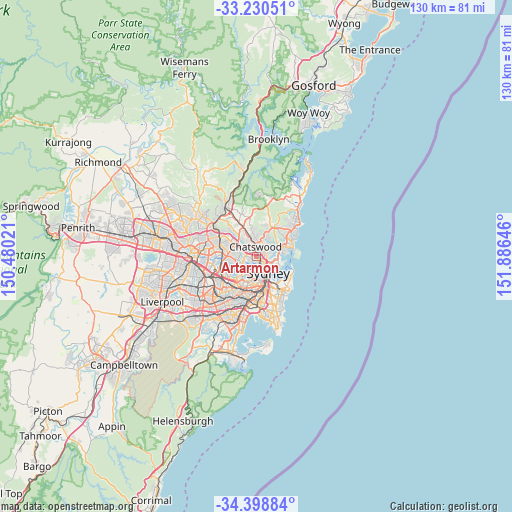
Artarmon GPS coordinates[2]
33° 49' 0.012" South, 151° 10' 59.988" East
| Map corner | latitude | longitude |
|---|---|---|
| Upper-left | -33.23051°, | 150.48021° |
| Center: | -33.81667°, | 151.18333° |
| Lower-right: | -34.39884°, | 151.88646° |
| Map W x H: | 129.9×129.9 km | = 80.7×80.7mi |
| max Lat: | -10.58257° ⇑52.4% North |
| Artarmon: | -33.81667° |
| min Lat: | ⇓47.6% South -43.31423° |
| min Long | Artarmon | max Long |
| 113.53327° | 151.18333° | 153.61246° |
| W 72.6%⇐ | ⇒27.4% E |
Elevation
Elevation of Artarmon is 99 m = 325 ft, and this is 23 m = 75 ft below average elevation for this country.
| Max E: |
1715 m = 5627 ft | 30.6% |
| Avg. | 122 m = 400 ft | |
| Artarmon | 99 m = 325 ft | |
Min E: |
-2 m = -7 ft | 69.4% |
See also: Australia elevation on elevation.city.
Geographical zone
Artarmon is located in South temperate zone (between Tropic of Capricorn and the Antarctic Circle). Distance of this Southern Tropic circle is 1154.1 km =717.1 mi to North.| Distance of | km | miles | from Artarmon |
|---|---|---|---|
| Equator | 3760.1 | 2336.4 | to North |
| Tropic Capricorn | 1154.1 | 717.1 | to North |
| Antarctic Circle | 3641.1 | 2262.5 | to South |
| South Pole | 6247 | 3881.7 | to South |


Nearby cities:
15 places around Artarmon: (largest is in red/bold)
• Chatswood
1.9 km =1.2 mi,  0°
0°
• Crows Nest
2.1 km =1.3 mi,  115°
115°
• Greenwich
2.5 km =1.6 mi,  180°
180°
• Lane Cove
1.5 km =0.9 mi,  274°
274°
• Lane Cove North
2 km =1.2 mi,  308°
308°
• Longueville
2.5 km =1.6 mi,  222°
222°
• Naremburn
1.6 km =1 mi,  91°
91°
• North Willoughby
2.8 km =1.7 mi,  34°
34°
• Northwood
1.4 km =0.9 mi,  191°
191°
• Riverview
2.1 km =1.3 mi,  245°
245°
• St Leonards
1.6 km =1 mi, 118°
• Waverton
2.9 km =1.8 mi,  147°
147°
• Willoughby
2 km =1.2 mi,  48°
48°
• Willoughby East
2.9 km =1.8 mi,  44°
44°
• Wollstonecraft
1.9 km =1.2 mi,  161°
161°
Sources, notices
• [Note1] Compared only with cities in Australia existing in our database
• [Src1] Map data: © OpenStreetMap contributors (CC-BY-SA)
• [Src2] Other city data from geonames.org with taken over terms of usage.
• [Src3] Geographical zone / Annual Mean Temperature by Robert A. Rohde @ Wikipedia
