Blue Mountain Heights geodata
Blue Mountain Heights (Queensland) is a section of populated place; located in Australia in Australia/Brisbane (GMT+10) time zone. With population of 887 people, there are 3993 cities with bigger population in this country. Compared to other cities in Australia, 81.9% of cities are located further ↓South; 82.3% of cities are located further ←West and 98.5% of cities have lower elevation than Blue Mountain Heights. Note1
Current local time in Blue Mountain Heights:
11:58 AM, ThursdayDifference from your time zone: hours


Blue Mountain Heights GPS coordinates[2]
27° 30' 17.568" South, 151° 57' 21.24" East
| Map corner | latitude | longitude |
|---|---|---|
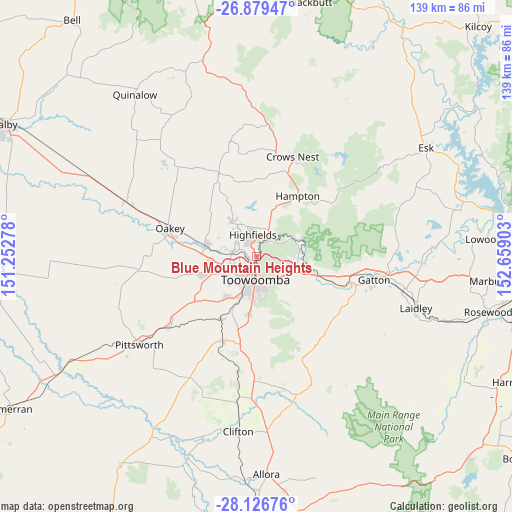
| Upper-left | -26.87947°, | 151.25278° |
| Center: | -27.50488°, | 151.9559° |
| Lower-right: | -28.12676°, | 152.65903° |
| Map W x H: | 138.7×138.7 km | = 86.2×86.2mi |
| max Lat: | -10.58257° ⇑18.1% North |
| Blue Mountain Heights: | -27.50488° |
| min Lat: | ⇓81.9% South -43.31423° |
| min Long | Blue Mountain H | max Long |
| 113.53327° | 151.9559° | 153.61246° |
| W 82.3%⇐ | ⇒17.7% E |
Elevation
Elevation of Blue Mountain Heights is 704 m = 2310 ft, and this is 582 m = 1909 ft above average elevation for this country.
| Max E: |
1715 m = 5627 ft | 1.5% |
| Blue Mountain Heights | 704 m 2310 ft | |
| Avg. | 122 m = 400 ft | |
Min E: |
-2 m = -7 ft | 98.5% |
See also: Australia elevation on elevation.city.
Geographical zone
Blue Mountain Heights is located in South temperate zone (between Tropic of Capricorn and the Antarctic Circle). Distance of this Southern Tropic circle is 452.3 km =281 mi to North.| Distance of | km | miles | from Blue Mountain Heights |
|---|---|---|---|
| Equator | 3058.3 | 1900.3 | to North |
| Tropic Capricorn | 452.3 | 281 | to North |
| Antarctic Circle | 4342.9 | 2698.6 | to South |
| South Pole | 6948.8 | 4317.8 | to South |


Nearby cities:
15 places around Blue Mountain Heights: (largest is in red/bold)
• Cotswold Hills
6.3 km =3.9 mi,  251°
251°
• Cranley
3.4 km =2.1 mi, 250°
• East Toowoomba
7.6 km =4.7 mi,  166°
166°
• Gowrie Junction
7.5 km =4.7 mi,  288°
288°
• Harlaxton
3.3 km =2.1 mi,  161°
161°
• Highfields
4.6 km =2.9 mi,  357°
357°
• Mount Lofty
4.9 km =3 mi, 160°
• Newtown
6.1 km =3.8 mi,  202°
202°
• North Toowoomba
4.4 km =2.7 mi, 173°
• Prince Henry Heights
6.2 km =3.9 mi,  146°
146°
• Rockville
3.9 km =2.4 mi,  206°
206°
• South Toowoomba
7.4 km =4.6 mi,  187°
187°
• Toowoomba
6.2 km =3.9 mi,  181°
181°
• Wilsonton
5.7 km =3.5 mi,  222°
222°
• Wilsonton Heights
4.3 km =2.7 mi,  225°
225°
Sources, notices
• [Note1] Compared only with cities in Australia existing in our database
• [Src1] Map data: © OpenStreetMap contributors (CC-BY-SA)
• [Src2] Other city data from geonames.org with taken over terms of usage.
• [Src3] Geographical zone / Annual Mean Temperature by Robert A. Rohde @ Wikipedia
