Brightwaters geodata
Brightwaters (New South Wales) is a section of populated place; located in Australia in Australia/Sydney (GMT+11) time zone. With population of 858 people, there are 4050 cities with bigger population in this country. Compared to other cities in Australia, 56.6% of cities are located further ↓South; 78.2% of cities are located further ←West and 69.8% of cities have higher elevation than Brightwaters. Note1


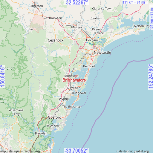
Brightwaters GPS coordinates[2]
33° 6' 48.852" South, 151° 32' 40.992" East
| Map corner | latitude | longitude |
|---|---|---|
| Upper-left | -32.52267°, | 150.8416° |
| Center: | -33.11357°, | 151.54472° |
| Lower-right: | -33.70052°, | 152.24785° |
| Map W x H: | 131×131 km | = 81.4×81.4mi |
| max Lat: | -10.58257° ⇑43.4% North |
| Brightwaters: | -33.11357° |
| min Lat: | ⇓56.6% South -43.31423° |
| min Long | Brightwaters | max Long |
| 113.53327° | 151.54472° | 153.61246° |
| W 78.2%⇐ | ⇒21.8% E |
Elevation
Elevation of Brightwaters is 23 m = 75 ft, and this is 99 m = 325 ft below average elevation for this country.
| Max E: |
1715 m = 5627 ft | 69.8% |
| Avg. | 122 m = 400 ft | |
| Brightwaters | 23 m = 75 ft | |
Min E: |
-2 m = -7 ft | 30.2% |
See also: Australia elevation on elevation.city.
Geographical zone
Brightwaters is located in South temperate zone (between Tropic of Capricorn and the Antarctic Circle). Distance of this Southern Tropic circle is 1076 km =668.6 mi to North.| Distance of | km | miles | from Brightwaters |
|---|---|---|---|
| Equator | 3681.9 | 2287.8 | to North |
| Tropic Capricorn | 1076 | 668.6 | to North |
| Antarctic Circle | 3719.3 | 2311.1 | to South |
| South Pole | 6325.2 | 3930.3 | to South |


Nearby cities:
15 places around Brightwaters: (largest is in red/bold)
• Arcadia vale
6.9 km =4.3 mi,  31°
31°
• Balcolyn
2.1 km =1.3 mi,  18°
18°
• Bonnells Bay
1.2 km =0.7 mi,  290°
290°
• Chain Valley Bay
7 km =4.3 mi,  159°
159°
• Dora Creek
5.7 km =3.5 mi,  308°
308°
• Gwandalan
4.3 km =2.7 mi,  124°
124°
• Mannering Park
5 km =3.1 mi,  190°
190°
• Mirrabooka
0.9 km =0.6 mi,  72°
72°
• Morisset
5.4 km =3.4 mi,  276°
276°
• Morisset Park
1 km =0.6 mi,  226°
226°
• Nords Wharf
6.1 km =3.8 mi,  108°
108°
• Summerland Point
3.6 km =2.2 mi,  147°
147°
• Wangi Wangi
6.8 km =4.2 mi,  47°
47°
• Windermere Park
1.5 km =0.9 mi,  237°
237°
• Wyee Point
5 km =3.1 mi,  223°
223°
Sources, notices
• [Note1] Compared only with cities in Australia existing in our database
• [Src1] Map data: © OpenStreetMap contributors (CC-BY-SA)
• [Src2] Other city data from geonames.org with taken over terms of usage.
• [Src3] Geographical zone / Annual Mean Temperature by Robert A. Rohde @ Wikipedia
