Balcolyn geodata
Balcolyn (New South Wales) is a section of populated place; located in Australia in Australia/Sydney (GMT+11) time zone. With population of 939 people, there are 3917 cities with bigger population in this country. Compared to other cities in Australia, 56.8% of cities are located further ↓South; 78.3% of cities are located further ←West and 90.1% of cities have higher elevation than Balcolyn. Note1


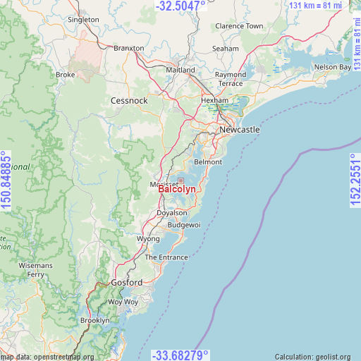
Balcolyn GPS coordinates[2]
33° 5' 44.592" South, 151° 33' 7.092" East
| Map corner | latitude | longitude |
|---|---|---|
| Upper-left | -32.5047°, | 150.84885° |
| Center: | -33.09572°, | 151.55197° |
| Lower-right: | -33.68279°, | 152.2551° |
| Map W x H: | 131×131 km | = 81.4×81.4mi |
| max Lat: | -10.58257° ⇑43.2% North |
| Balcolyn: | -33.09572° |
| min Lat: | ⇓56.8% South -43.31423° |
| min Long | Balcolyn | max Long |
| 113.53327° | 151.55197° | 153.61246° |
| W 78.3%⇐ | ⇒21.7% E |
Elevation
Elevation of Balcolyn is 9 m = 30 ft, and this is 113 m = 371 ft below average elevation for this country.
| Max E: |
1715 m = 5627 ft | 90.1% |
| Avg. | 122 m = 400 ft | |
| Balcolyn | 9 m = 30 ft | |
Min E: |
-2 m = -7 ft | 9.9% |
See also: Australia elevation on elevation.city.
Geographical zone
Balcolyn is located in South temperate zone (between Tropic of Capricorn and the Antarctic Circle). Distance of this Southern Tropic circle is 1074 km =667.4 mi to North.| Distance of | km | miles | from Balcolyn |
|---|---|---|---|
| Equator | 3679.9 | 2286.6 | to North |
| Tropic Capricorn | 1074 | 667.4 | to North |
| Antarctic Circle | 3721.3 | 2312.3 | to South |
| South Pole | 6327.2 | 3931.5 | to South |


Nearby cities:
15 places around Balcolyn: (largest is in red/bold)
• Arcadia vale
4.9 km =3 mi,  37°
37°
• Bonnells Bay
2.4 km =1.5 mi,  229°
229°
• Brightwaters
2.1 km =1.3 mi,  198°
198°
• Buttaba
5.3 km =3.3 mi,  27°
27°
• Dora Creek
5.4 km =3.4 mi,  287°
287°
• Fishing Point
6.1 km =3.8 mi, 40°
• Gwandalan
5.3 km =3.3 mi,  146°
146°
• Mirrabooka
1.7 km =1.1 mi,  172°
172°
• Morisset
6.2 km =3.9 mi,  257°
257°
• Morisset Park
3 km =1.9 mi,  207°
207°
• Murrays Beach
6.9 km =4.3 mi,  110°
110°
• Nords Wharf
6.5 km =4 mi,  127°
127°
• Summerland Point
5.2 km =3.2 mi, 165°
• Wangi Wangi
5.1 km =3.2 mi,  58°
58°
• Windermere Park
3.4 km =2.1 mi,  215°
215°
Sources, notices
• [Note1] Compared only with cities in Australia existing in our database
• [Src1] Map data: © OpenStreetMap contributors (CC-BY-SA)
• [Src2] Other city data from geonames.org with taken over terms of usage.
• [Src3] Geographical zone / Annual Mean Temperature by Robert A. Rohde @ Wikipedia
