Summerland Point geodata
Summerland Point (New South Wales) is a section of populated place; located in Australia in Australia/Sydney (GMT+11) time zone. With population of 2,424 people, there are 2615 cities with bigger population in this country. Compared to other cities in Australia, 56.5% of cities are located further ↓South; 78.5% of cities are located further ←West and 88.3% of cities have higher elevation than Summerland Point. Note1


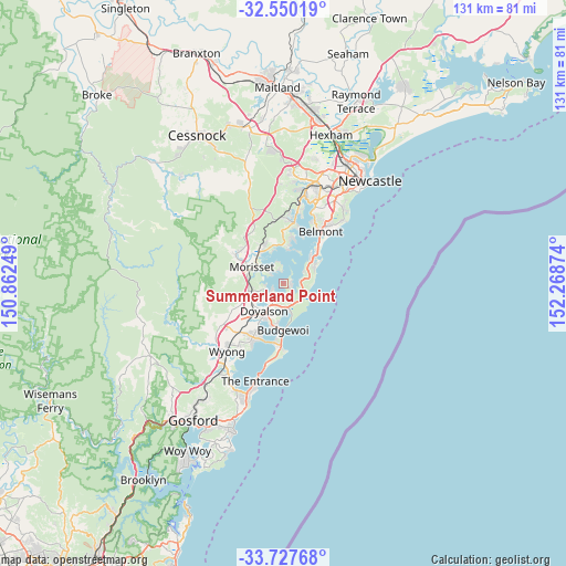
Summerland Point GPS coordinates[2]
33° 8' 27.276" South, 151° 33' 56.196" East
| Map corner | latitude | longitude |
|---|---|---|
| Upper-left | -32.55019°, | 150.86249° |
| Center: | -33.14091°, | 151.56561° |
| Lower-right: | -33.72768°, | 152.26874° |
| Map W x H: | 130.9×130.9 km | = 81.3×81.3mi |
| max Lat: | -10.58257° ⇑43.5% North |
| Summerland Point: | -33.14091° |
| min Lat: | ⇓56.5% South -43.31423° |
| min Long | Summerland Poin | max Long |
| 113.53327° | 151.56561° | 153.61246° |
| W 78.5%⇐ | ⇒21.5% E |
Elevation
Elevation of Summerland Point is 10 m = 33 ft, and this is 112 m = 367 ft below average elevation for this country.
| Max E: |
1715 m = 5627 ft | 88.3% |
| Avg. | 122 m = 400 ft | |
| Summerland Point | 10 m = 33 ft | |
Min E: |
-2 m = -7 ft | 11.7% |
See also: Australia elevation on elevation.city.
Geographical zone
Summerland Point is located in South temperate zone (between Tropic of Capricorn and the Antarctic Circle). Distance of this Southern Tropic circle is 1079 km =670.5 mi to North.| Distance of | km | miles | from Summerland Point |
|---|---|---|---|
| Equator | 3684.9 | 2289.7 | to North |
| Tropic Capricorn | 1079 | 670.5 | to North |
| Antarctic Circle | 3716.3 | 2309.2 | to South |
| South Pole | 6322.1 | 3928.4 | to South |


Nearby cities:
15 places around Summerland Point: (largest is in red/bold)
• Balcolyn
5.2 km =3.2 mi,  345°
345°
• Bonnells Bay
4.7 km =2.9 mi,  318°
318°
• Brightwaters
3.6 km =2.2 mi,  327°
327°
• Caves Beach
8.2 km =5.1 mi,  62°
62°
• Chain Valley Bay
3.5 km =2.2 mi,  171°
171°
• Gwandalan
1.7 km =1.1 mi,  69°
69°
• Lake Munmorah
6.4 km =4 mi, 165°
• Mannering Park
3.4 km =2.1 mi,  236°
236°
• Mirrabooka
3.5 km =2.2 mi,  342°
342°
• Morisset
8.2 km =5.1 mi,  296°
296°
• Morisset Park
3.6 km =2.2 mi,  311°
311°
• Murrays Beach
5.8 km =3.6 mi, 63°
• Nords Wharf
4 km =2.5 mi, 74°
• Windermere Park
3.9 km =2.4 mi, 304°
• Wyee Point
5.4 km =3.4 mi,  264°
264°
Sources, notices
• [Note1] Compared only with cities in Australia existing in our database
• [Src1] Map data: © OpenStreetMap contributors (CC-BY-SA)
• [Src2] Other city data from geonames.org with taken over terms of usage.
• [Src3] Geographical zone / Annual Mean Temperature by Robert A. Rohde @ Wikipedia
