Mudjimba geodata
Mudjimba (Queensland) is a section of populated place; located in Australia in Australia/Brisbane (GMT+10) time zone. With population of 2,710 people, there are 2428 cities with bigger population in this country. Compared to other cities in Australia, 87.2% of cities are located further ↓South; 94.8% of cities are located further ←West and 96.8% of cities have higher elevation than Mudjimba. Note1


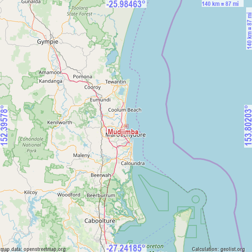
Mudjimba GPS coordinates[2]
26° 36' 53.892" South, 153° 5' 56.04" East
| Map corner | latitude | longitude |
|---|---|---|
| Upper-left | -25.98463°, | 152.39578° |
| Center: | -26.61497°, | 153.0989° |
| Lower-right: | -27.24185°, | 153.80203° |
| Map W x H: | 139.8×139.8 km | = 86.9×86.9mi |
| max Lat: | -10.58257° ⇑12.8% North |
| Mudjimba: | -26.61497° |
| min Lat: | ⇓87.2% South -43.31423° |
| min Long | Mudjimba | max Long |
| 113.53327° | 153.0989° | 153.61246° |
| W 94.8%⇐ | ⇒5.2% E |
Elevation
Elevation of Mudjimba is 5 m = 16 ft, and this is 117 m = 384 ft below average elevation for this country.
| Max E: |
1715 m = 5627 ft | 96.8% |
| Avg. | 122 m = 400 ft | |
| Mudjimba | 5 m = 16 ft | |
Min E: |
-2 m = -7 ft | 3.2% |
See also: Australia elevation on elevation.city.
Geographical zone
Mudjimba is located in South temperate zone (between Tropic of Capricorn and the Antarctic Circle). Distance of this Southern Tropic circle is 353.4 km =219.6 mi to North.| Distance of | km | miles | from Mudjimba |
|---|---|---|---|
| Equator | 2959.3 | 1838.8 | to North |
| Tropic Capricorn | 353.4 | 219.6 | to North |
| Antarctic Circle | 4441.9 | 2760.1 | to South |
| South Pole | 7047.8 | 4379.3 | to South |


Nearby cities:
15 places around Mudjimba: (largest is in red/bold)
• Alexandra Headland
6.3 km =3.9 mi,  178°
178°
• Bli Bli
6.2 km =3.9 mi,  267°
267°
• Buderim
8.8 km =5.5 mi,  208°
208°
• Diddillibah
5.7 km =3.5 mi,  238°
238°
• Kuluin
6.4 km =4 mi,  221°
221°
• Marcoola
3.4 km =2.1 mi,  352°
352°
• Maroochy River
9 km =5.6 mi,  297°
297°
• Maroochydore
5 km =3.1 mi, 179°
• Minyama
9.3 km =5.8 mi,  164°
164°
• Mooloolaba
7.7 km =4.8 mi, 164°
• Mount Coolum
5.5 km =3.4 mi, 352°
• Pacific Paradise
2.1 km =1.3 mi,  260°
260°
• Sunshine Coast
5 km =3.1 mi,  202°
202°
• Twin Waters
2.8 km =1.7 mi, 219°
• Yaroomba
7.1 km =4.4 mi,  358°
358°
Sources, notices
• [Note1] Compared only with cities in Australia existing in our database
• [Src1] Map data: © OpenStreetMap contributors (CC-BY-SA)
• [Src2] Other city data from geonames.org with taken over terms of usage.
• [Src3] Geographical zone / Annual Mean Temperature by Robert A. Rohde @ Wikipedia
