Maroochydore geodata
Maroochydore (Queensland) is a section of populated place; located in Australia in Australia/Brisbane (GMT+10) time zone. With population of 18,342 people, there are 189 cities with bigger population in this country. Compared to other cities in Australia, 86.8% of cities are located further ↓South; 94.8% of cities are located further ←West and 95.5% of cities have higher elevation than Maroochydore. Note1


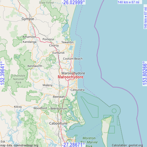
Maroochydore GPS coordinates[2]
26° 39' 36.288" South, 153° 5' 58.308" East
| Map corner | latitude | longitude |
|---|---|---|
| Upper-left | -26.02999°, | 152.39641° |
| Center: | -26.66008°, | 153.09953° |
| Lower-right: | -27.28671°, | 153.80266° |
| Map W x H: | 139.7×139.7 km | = 86.8×86.8mi |
| max Lat: | -10.58257° ⇑13.2% North |
| Maroochydore: | -26.66008° |
| min Lat: | ⇓86.8% South -43.31423° |
| min Long | Maroochydore | max Long |
| 113.53327° | 153.09953° | 153.61246° |
| W 94.8%⇐ | ⇒5.2% E |
Elevation
Elevation of Maroochydore is 6 m = 20 ft, and this is 116 m = 381 ft below average elevation for this country.
| Max E: |
1715 m = 5627 ft | 95.5% |
| Avg. | 122 m = 400 ft | |
| Maroochydore | 6 m = 20 ft | |
Min E: |
-2 m = -7 ft | 4.5% |
See also: Australia elevation on elevation.city.
Geographical zone
Maroochydore is located in South temperate zone (between Tropic of Capricorn and the Antarctic Circle). Distance of this Southern Tropic circle is 358.4 km =222.7 mi to North.| Distance of | km | miles | from Maroochydore |
|---|---|---|---|
| Equator | 2964.3 | 1841.9 | to North |
| Tropic Capricorn | 358.4 | 222.7 | to North |
| Antarctic Circle | 4436.9 | 2757 | to South |
| South Pole | 7042.7 | 4376.1 | to South |


Nearby cities:
15 places around Maroochydore: (largest is in red/bold)
• Alexandra Headland
1.3 km =0.8 mi,  175°
175°
• Buddina
5.2 km =3.2 mi,  139°
139°
• Buderim
5 km =3.1 mi,  237°
237°
• Diddillibah
5.4 km =3.4 mi,  292°
292°
• Kuluin
4.3 km =2.7 mi,  273°
273°
• Minyama
4.6 km =2.9 mi,  148°
148°
• Mooloolaba
3.1 km =1.9 mi, 140°
• Mountain Creek
4.8 km =3 mi, 177°
• Mudjimba
5 km =3.1 mi,  359°
359°
• Pacific Paradise
5.1 km =3.2 mi,  335°
335°
• Parrearra
6.1 km =3.8 mi,  158°
158°
• Sippy Downs
7.8 km =4.8 mi,  214°
214°
• Sunshine Coast
2 km =1.2 mi,  280°
280°
• Twin Waters
3.4 km =2.1 mi,  327°
327°
• Warana
7.5 km =4.7 mi, 158°
Sources, notices
• [Note1] Compared only with cities in Australia existing in our database
• [Src1] Map data: © OpenStreetMap contributors (CC-BY-SA)
• [Src2] Other city data from geonames.org with taken over terms of usage.
• [Src3] Geographical zone / Annual Mean Temperature by Robert A. Rohde @ Wikipedia
