Kuluin geodata
Kuluin (Queensland) is a section of populated place; located in Australia in Australia/Brisbane (GMT+10) time zone. With population of 2,351 people, there are 2660 cities with bigger population in this country. Compared to other cities in Australia, 86.9% of cities are located further ↓South; 93.2% of cities are located further ←West and 77.5% of cities have higher elevation than Kuluin. Note1


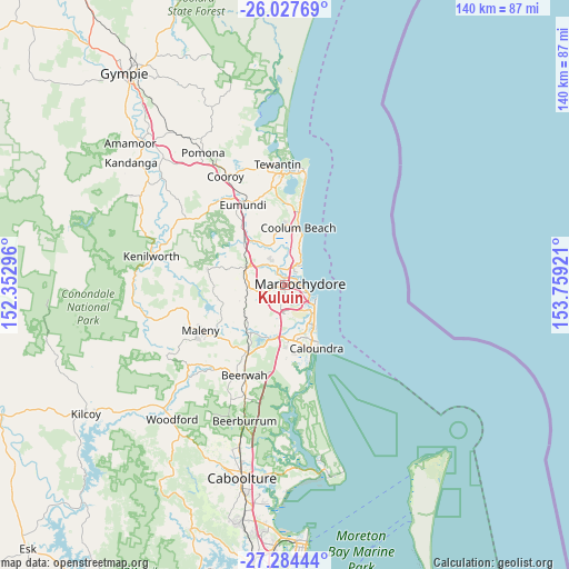
Kuluin GPS coordinates[2]
26° 39' 28.044" South, 153° 3' 21.888" East
| Map corner | latitude | longitude |
|---|---|---|
| Upper-left | -26.02769°, | 152.35296° |
| Center: | -26.65779°, | 153.05608° |
| Lower-right: | -27.28444°, | 153.75921° |
| Map W x H: | 139.7×139.7 km | = 86.8×86.8mi |
| max Lat: | -10.58257° ⇑13.1% North |
| Kuluin: | -26.65779° |
| min Lat: | ⇓86.9% South -43.31423° |
| min Long | Kuluin | max Long |
| 113.53327° | 153.05608° | 153.61246° |
| W 93.2%⇐ | ⇒6.8% E |
Elevation
Elevation of Kuluin is 17 m = 56 ft, and this is 105 m = 344 ft below average elevation for this country.
| Max E: |
1715 m = 5627 ft | 77.5% |
| Avg. | 122 m = 400 ft | |
| Kuluin | 17 m = 56 ft | |
Min E: |
-2 m = -7 ft | 22.5% |
See also: Australia elevation on elevation.city.
Geographical zone
Kuluin is located in South temperate zone (between Tropic of Capricorn and the Antarctic Circle). Distance of this Southern Tropic circle is 358.1 km =222.5 mi to North.| Distance of | km | miles | from Kuluin |
|---|---|---|---|
| Equator | 2964.1 | 1841.8 | to North |
| Tropic Capricorn | 358.1 | 222.5 | to North |
| Antarctic Circle | 4437.1 | 2757.1 | to South |
| South Pole | 7043 | 4376.3 | to South |


Nearby cities:
15 places around Kuluin: (largest is in red/bold)
• Alexandra Headland
4.7 km =2.9 mi,  109°
109°
• Bli Bli
4.9 km =3 mi,  336°
336°
• Buderim
3 km =1.9 mi,  178°
178°
• Diddillibah
1.9 km =1.2 mi, 340°
• Forest Glen
6.2 km =3.9 mi,  236°
236°
• Kiels Mountain
4.8 km =3 mi,  271°
271°
• Maroochydore
4.3 km =2.7 mi,  93°
93°
• Mons
4.9 km =3 mi,  219°
219°
• Mountain Creek
6.7 km =4.2 mi,  138°
138°
• Mudjimba
6.4 km =4 mi,  41°
41°
• Pacific Paradise
4.9 km =3 mi,  26°
26°
• Rosemount
6.4 km =4 mi,  298°
298°
• Sippy Downs
6.7 km =4.2 mi, 181°
• Sunshine Coast
2.3 km =1.4 mi, 87°
• Twin Waters
3.6 km =2.2 mi, 43°
Sources, notices
• [Note1] Compared only with cities in Australia existing in our database
• [Src1] Map data: © OpenStreetMap contributors (CC-BY-SA)
• [Src2] Other city data from geonames.org with taken over terms of usage.
• [Src3] Geographical zone / Annual Mean Temperature by Robert A. Rohde @ Wikipedia
