Nelly Bay geodata
Nelly Bay (Queensland) is a section of populated place; located in Australia in Australia/Brisbane (GMT+10) time zone. With population of 1,661 people, there are 3128 cities with bigger population in this country. Compared to other cities in Australia, 95.8% of cities are located further ↓South; 53.8% of cities are located further →East and 83.5% of cities have higher elevation than Nelly Bay. Note1


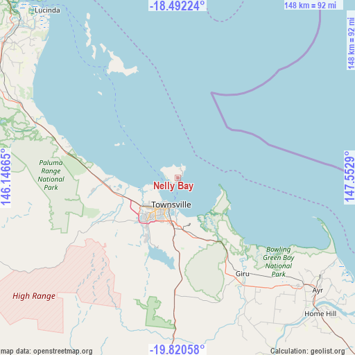
Nelly Bay GPS coordinates[2]
19° 9' 27.9" South, 146° 50' 59.172" East
| Map corner | latitude | longitude |
|---|---|---|
| Upper-left | -18.49224°, | 146.14665° |
| Center: | -19.15775°, | 146.84977° |
| Lower-right: | -19.82058°, | 147.5529° |
| Map W x H: | 147.7×147.7 km | = 91.8×91.8mi |
| max Lat: | -10.58257° ⇑4.2% North |
| Nelly Bay: | -19.15775° |
| min Lat: | ⇓95.8% South -43.31423° |
| min Long | Nelly Bay | max Long |
| 113.53327° | 146.84977° | 153.61246° |
| W 46.2%⇐ | ⇒53.8% E |
Elevation
Elevation of Nelly Bay is 13 m = 43 ft, and this is 109 m = 358 ft below average elevation for this country.
| Max E: |
1715 m = 5627 ft | 83.5% |
| Avg. | 122 m = 400 ft | |
| Nelly Bay | 13 m = 43 ft | |
Min E: |
-2 m = -7 ft | 16.5% |
See also: Australia elevation on elevation.city.
Geographical zone
Nelly Bay is located in South Torrid zone (between Equator and Tropic of Capricorn). Distance of this Southern Tropic circle is 475.8 km =295.6 mi to South.| Distance of | km | miles | from Nelly Bay |
|---|---|---|---|
| Equator | 2130.1 | 1323.6 | to North |
| Tropic Capricorn | 475.8 | 295.6 | to South |
| Antarctic Circle | 5271 | 3275.2 | to South |
| South Pole | 7876.9 | 4894.5 | to South |


Nearby cities:
15 places around Nelly Bay: (largest is in red/bold)
• Belgian Gardens
11.3 km =7 mi,  210°
210°
• Castle Hill
12.3 km =7.6 mi,  204°
204°
• Currajong
15.1 km =9.4 mi, 209°
• Garbutt
14 km =8.7 mi, 210°
• Horseshoe Bay
4.6 km =2.9 mi,  14°
14°
• Hyde Park
14.4 km =8.9 mi, 202°
• Magnetic Island
0.3 km =0.2 mi,  335°
335°
• North Ward
10.9 km =6.8 mi, 199°
• Pallarenda
9.4 km =5.8 mi,  239°
239°
• Pimlico
15.2 km =9.4 mi, 205°
• Railway Estate
13.5 km =8.4 mi,  193°
193°
• Rowes Bay
11.1 km =6.9 mi, 214°
• South Townsville
12.2 km =7.6 mi, 188°
• Townsville
12.9 km =8 mi, 200°
• West End
13.5 km =8.4 mi, 205°
Sources, notices
• [Note1] Compared only with cities in Australia existing in our database
• [Src1] Map data: © OpenStreetMap contributors (CC-BY-SA)
• [Src2] Other city data from geonames.org with taken over terms of usage.
• [Src3] Geographical zone / Annual Mean Temperature by Robert A. Rohde @ Wikipedia
