Ningi geodata
Ningi (Queensland) is a section of populated place; located in Australia in Australia/Brisbane (GMT+10) time zone. With population of 4,599 people, there are 1599 cities with bigger population in this country. Compared to other cities in Australia, 85.5% of cities are located further ↓South; 94.1% of cities are located further ←West and 80.4% of cities have higher elevation than Ningi. Note1


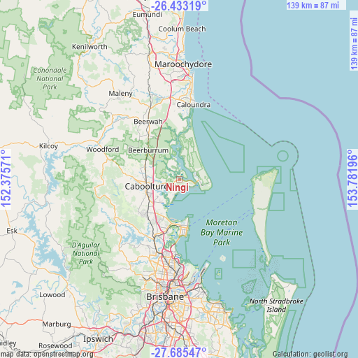
Ningi GPS coordinates[2]
27° 3' 39.888" South, 153° 4' 43.788" East
| Map corner | latitude | longitude |
|---|---|---|
| Upper-left | -26.43319°, | 152.37571° |
| Center: | -27.06108°, | 153.07883° |
| Lower-right: | -27.68547°, | 153.78196° |
| Map W x H: | 139.2×139.2 km | = 86.5×86.5mi |
| max Lat: | -10.58257° ⇑14.5% North |
| Ningi: | -27.06108° |
| min Lat: | ⇓85.5% South -43.31423° |
| min Long | Ningi | max Long |
| 113.53327° | 153.07883° | 153.61246° |
| W 94.1%⇐ | ⇒5.9% E |
Elevation
Elevation of Ningi is 15 m = 49 ft, and this is 107 m = 351 ft below average elevation for this country.
| Max E: |
1715 m = 5627 ft | 80.4% |
| Avg. | 122 m = 400 ft | |
| Ningi | 15 m = 49 ft | |
Min E: |
-2 m = -7 ft | 19.6% |
See also: Australia elevation on elevation.city.
Geographical zone
Ningi is located in South temperate zone (between Tropic of Capricorn and the Antarctic Circle). Distance of this Southern Tropic circle is 403 km =250.4 mi to North.| Distance of | km | miles | from Ningi |
|---|---|---|---|
| Equator | 3008.9 | 1869.6 | to North |
| Tropic Capricorn | 403 | 250.4 | to North |
| Antarctic Circle | 4392.3 | 2729.2 | to South |
| South Pole | 6998.2 | 4348.5 | to South |


Nearby cities:
15 places around Ningi: (largest is in red/bold)
• Banksia Beach
6.8 km =4.2 mi,  70°
70°
• Beachmere
7.9 km =4.9 mi,  199°
199°
• Bellara
7 km =4.3 mi,  92°
92°
• Bongaree
8.4 km =5.2 mi,  107°
107°
• Burpengary East
12.1 km =7.5 mi,  220°
220°
• Caboolture
12.9 km =8 mi,  258°
258°
• Caboolture South
13.4 km =8.3 mi,  254°
254°
• Deception Bay
15.6 km =9.7 mi, 199°
• Donnybrook
6.3 km =3.9 mi,  349°
349°
• Elimbah
13.7 km =8.5 mi,  291°
291°
• Morayfield
13.9 km =8.6 mi, 247°
• Sandstone Point
5.9 km =3.7 mi,  115°
115°
• Scarborough
15.9 km =9.9 mi,  169°
169°
• Toorbul
3.7 km =2.3 mi,  30°
30°
• Woorim
12.5 km =7.8 mi, 94°
Sources, notices
• [Note1] Compared only with cities in Australia existing in our database
• [Src1] Map data: © OpenStreetMap contributors (CC-BY-SA)
• [Src2] Other city data from geonames.org with taken over terms of usage.
• [Src3] Geographical zone / Annual Mean Temperature by Robert A. Rohde @ Wikipedia
