Leederville geodata
Leederville (Western Australia) is a section of populated place; located in Australia in Australia/Perth (GMT+8) time zone. With population of 3,053 people, there are 2222 cities with bigger population in this country. Compared to other cities in Australia, 66.1% of cities are located further ↓South; 95% of cities are located further →East and 74.7% of cities have higher elevation than Leederville. Note1


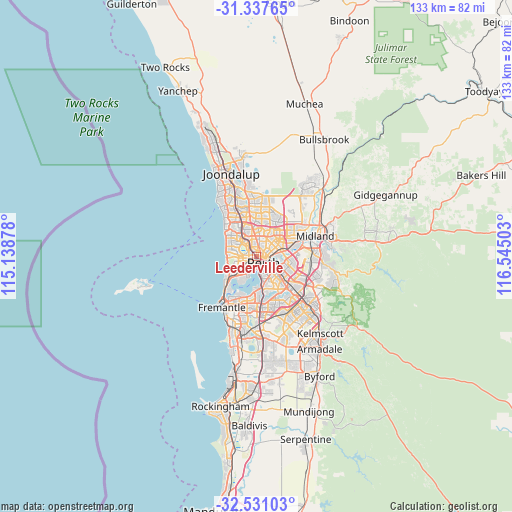
Leederville GPS coordinates[2]
31° 56' 10.608" South, 115° 50' 30.84" East
| Map corner | latitude | longitude |
|---|---|---|
| Upper-left | -31.33765°, | 115.13878° |
| Center: | -31.93628°, | 115.8419° |
| Lower-right: | -32.53103°, | 116.54503° |
| Map W x H: | 132.7×132.7 km | = 82.5×82.5mi |
| max Lat: | -10.58257° ⇑33.9% North |
| Leederville: | -31.93628° |
| min Lat: | ⇓66.1% South -43.31423° |
| min Long | Leederville | max Long |
| 113.53327° | 115.8419° | 153.61246° |
| W 5%⇐ | ⇒95% E |
Elevation
Elevation of Leederville is 19 m = 62 ft, and this is 103 m = 338 ft below average elevation for this country.
| Max E: |
1715 m = 5627 ft | 74.7% |
| Avg. | 122 m = 400 ft | |
| Leederville | 19 m = 62 ft | |
Min E: |
-2 m = -7 ft | 25.3% |
See also: Australia elevation on elevation.city.
Geographical zone
Leederville is located in South temperate zone (between Tropic of Capricorn and the Antarctic Circle). Distance of this Southern Tropic circle is 945.1 km =587.3 mi to North.| Distance of | km | miles | from Leederville |
|---|---|---|---|
| Equator | 3551 | 2206.5 | to North |
| Tropic Capricorn | 945.1 | 587.3 | to North |
| Antarctic Circle | 3850.2 | 2392.4 | to South |
| South Pole | 6456.1 | 4011.6 | to South |


Nearby cities:
15 places around Leederville: (largest is in red/bold)
• Coolbinia
2.5 km =1.6 mi,  15°
15°
• Glendalough
2.8 km =1.7 mi,  310°
310°
• Highgate
2.7 km =1.7 mi,  98°
98°
• Joondanna
3.2 km =2 mi,  0°
0°
• Menora
2.7 km =1.7 mi,  44°
44°
• Mount Hawthorn
1.9 km =1.2 mi,  340°
340°
• Mount Lawley
2.8 km =1.7 mi,  85°
85°
• North Perth
1.4 km =0.9 mi,  45°
45°
• Northbridge
2 km =1.2 mi,  128°
128°
• Perth
2.6 km =1.6 mi, 133°
• Perth city centre
2.1 km =1.3 mi,  153°
153°
• Subiaco
2 km =1.2 mi,  226°
226°
• Wembley
2.3 km =1.4 mi,  278°
278°
• West Leederville
1.2 km =0.7 mi,  240°
240°
• West Perth
1.4 km =0.9 mi,  179°
179°
Sources, notices
• [Note1] Compared only with cities in Australia existing in our database
• [Src1] Map data: © OpenStreetMap contributors (CC-BY-SA)
• [Src2] Other city data from geonames.org with taken over terms of usage.
• [Src3] Geographical zone / Annual Mean Temperature by Robert A. Rohde @ Wikipedia
