Glendalough geodata
Glendalough (Western Australia) is a section of populated place; located in Australia in Australia/Perth (GMT+8) time zone. With population of 2,424 people, there are 2615 cities with bigger population in this country. Compared to other cities in Australia, 66.2% of cities are located further ↓South; 95.5% of cities are located further →East and 77.5% of cities have higher elevation than Glendalough. Note1


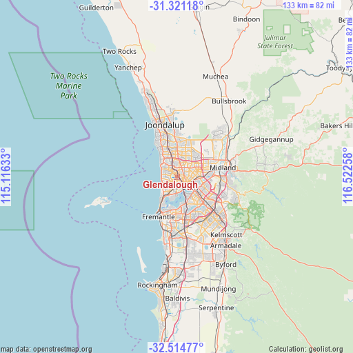
Glendalough GPS coordinates[2]
31° 55' 11.676" South, 115° 49' 10.02" East
| Map corner | latitude | longitude |
|---|---|---|
| Upper-left | -31.32118°, | 115.11633° |
| Center: | -31.91991°, | 115.81945° |
| Lower-right: | -32.51477°, | 116.52258° |
| Map W x H: | 132.7×132.7 km | = 82.5×82.5mi |
| max Lat: | -10.58257° ⇑33.8% North |
| Glendalough: | -31.91991° |
| min Lat: | ⇓66.2% South -43.31423° |
| min Long | Glendalough | max Long |
| 113.53327° | 115.81945° | 153.61246° |
| W 4.5%⇐ | ⇒95.5% E |
Elevation
Elevation of Glendalough is 17 m = 56 ft, and this is 105 m = 344 ft below average elevation for this country.
| Max E: |
1715 m = 5627 ft | 77.5% |
| Avg. | 122 m = 400 ft | |
| Glendalough | 17 m = 56 ft | |
Min E: |
-2 m = -7 ft | 22.5% |
See also: Australia elevation on elevation.city.
Geographical zone
Glendalough is located in South temperate zone (between Tropic of Capricorn and the Antarctic Circle). Distance of this Southern Tropic circle is 943.2 km =586.1 mi to North.| Distance of | km | miles | from Glendalough |
|---|---|---|---|
| Equator | 3549.2 | 2205.4 | to North |
| Tropic Capricorn | 943.2 | 586.1 | to North |
| Antarctic Circle | 3852 | 2393.5 | to South |
| South Pole | 6457.9 | 4012.8 | to South |


Nearby cities:
15 places around Glendalough: (largest is in red/bold)
• Churchlands
2.5 km =1.6 mi,  266°
266°
• Coolbinia
2.8 km =1.7 mi,  78°
78°
• Daglish
3.7 km =2.3 mi,  195°
195°
• Floreat
3.3 km =2.1 mi,  231°
231°
• Jolimont
3 km =1.9 mi, 198°
• Joondanna
2.6 km =1.6 mi,  57°
57°
• Leederville
2.8 km =1.7 mi,  130°
130°
• Mount Hawthorn
1.5 km =0.9 mi,  90°
90°
• North Perth
3.2 km =2 mi,  104°
104°
• Osborne Park
2.3 km =1.4 mi,  339°
339°
• Subiaco
3.3 km =2.1 mi,  167°
167°
• Tuart Hill
2.8 km =1.7 mi,  31°
31°
• Wembley
1.5 km =0.9 mi,  185°
185°
• West Leederville
2.6 km =1.6 mi,  155°
155°
• Yokine
3.8 km =2.4 mi, 56°
Sources, notices
• [Note1] Compared only with cities in Australia existing in our database
• [Src1] Map data: © OpenStreetMap contributors (CC-BY-SA)
• [Src2] Other city data from geonames.org with taken over terms of usage.
• [Src3] Geographical zone / Annual Mean Temperature by Robert A. Rohde @ Wikipedia
