Perth geodata
Perth (Western Australia) is a seat of a first-order administrative division; located in Australia in Australia/Perth (GMT+8) time zone. With population of 1,896,548 people, there are 3 cities with bigger population in this country. Compared to other cities in Australia, 65.8% of cities are located further ↓South; 94.6% of cities are located further →East and 50.2% of cities have lower elevation than Perth. Note1


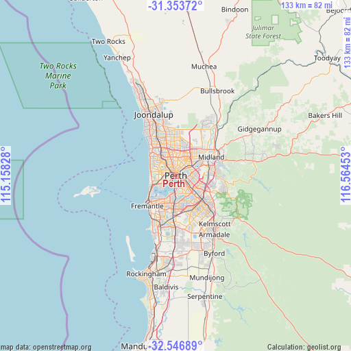
Perth GPS coordinates[2]
31° 57' 8.064" South, 115° 51' 41.04" East
| Map corner | latitude | longitude |
|---|---|---|
| Upper-left | -31.35372°, | 115.15828° |
| Center: | -31.95224°, | 115.8614° |
| Lower-right: | -32.54689°, | 116.56453° |
| Map W x H: | 132.7×132.7 km | = 82.5×82.5mi |
| max Lat: | -10.58257° ⇑34.2% North |
| Perth: | -31.95224° |
| min Lat: | ⇓65.8% South -43.31423° |
| min Long | Perth | max Long |
| 113.53327° | 115.8614° | 153.61246° |
| W 5.4%⇐ | ⇒94.6% E |
Elevation
Elevation of Perth is 46 m = 151 ft, and this is 76 m = 249 ft below average elevation for this country.
| Max E: |
1715 m = 5627 ft | 49.8% |
| Avg. | 122 m = 400 ft | |
| Perth | 46 m = 151 ft | |
Min E: |
-2 m = -7 ft | 50.2% |
See also: Perth elevation on elevation.city.
Geographical zone
Perth is located in South temperate zone (between Tropic of Capricorn and the Antarctic Circle). Distance of this Southern Tropic circle is 946.8 km =588.3 mi to North.| Distance of | km | miles | from Perth |
|---|---|---|---|
| Equator | 3552.8 | 2207.6 | to North |
| Tropic Capricorn | 946.8 | 588.3 | to North |
| Antarctic Circle | 3848.4 | 2391.3 | to South |
| South Pole | 6454.3 | 4010.5 | to South |


Nearby cities:
15 places around Perth: (largest is in red/bold)
• Burswood
4.1 km =2.5 mi,  100°
100°
• East Perth
1.2 km =0.7 mi,  128°
128°
• Highgate
1.6 km =1 mi,  30°
30°
• Inglewood
4.3 km =2.7 mi,  23°
23°
• Leederville
2.6 km =1.6 mi,  313°
313°
• Maylands
3.9 km =2.4 mi,  53°
53°
• Menora
3.7 km =2.3 mi,  0°
0°
• Mount Lawley
2.2 km =1.4 mi, 25°
• North Perth
2.9 km =1.8 mi,  343°
343°
• Northbridge
0.5 km =0.3 mi,  333°
333°
• Perth city centre
0.9 km =0.6 mi,  265°
265°
• South Perth
3.5 km =2.2 mi,  171°
171°
• Subiaco
3.3 km =2.1 mi,  277°
277°
• West Leederville
3.1 km =1.9 mi,  292°
292°
• West Perth
1.9 km =1.2 mi, 281°
Sources, notices
• [Note1] Compared only with cities in Australia existing in our database
• [Src1] Map data: © OpenStreetMap contributors (CC-BY-SA)
• [Src2] Other city data from geonames.org with taken over terms of usage.
• [Src3] Geographical zone / Annual Mean Temperature by Robert A. Rohde @ Wikipedia
