Acacia Gardens geodata
Acacia Gardens (New South Wales) is a section of populated place; located in Australia in Australia/Sydney (GMT+11) time zone. With population of 3,780 people, there are 1884 cities with bigger population in this country. Compared to other cities in Australia, 50.5% of cities are located further ↓South; 65.9% of cities are located further ←West and 66.8% of cities have lower elevation than Acacia Gardens. Note1


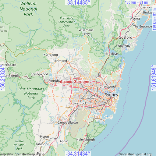
Acacia Gardens GPS coordinates[2]
33° 43' 53.724" South, 150° 54' 58.896" East
| Map corner | latitude | longitude |
|---|---|---|
| Upper-left | -33.14485°, | 150.21324° |
| Center: | -33.73159°, | 150.91636° |
| Lower-right: | -34.31434°, | 151.61949° |
| Map W x H: | 130×130 km | = 80.8×80.8mi |
| max Lat: | -10.58257° ⇑49.5% North |
| Acacia Gardens: | -33.73159° |
| min Lat: | ⇓50.5% South -43.31423° |
| min Long | Acacia Gardens | max Long |
| 113.53327° | 150.91636° | 153.61246° |
| W 65.9%⇐ | ⇒34.1% E |
Elevation
Elevation of Acacia Gardens is 87 m = 285 ft, and this is 35 m = 115 ft below average elevation for this country.
| Max E: |
1715 m = 5627 ft | 33.2% |
| Avg. | 122 m = 400 ft | |
| Acacia Gardens | 87 m = 285 ft | |
Min E: |
-2 m = -7 ft | 66.8% |
See also: Australia elevation on elevation.city.
Geographical zone
Acacia Gardens is located in South temperate zone (between Tropic of Capricorn and the Antarctic Circle). Distance of this Southern Tropic circle is 1144.7 km =711.3 mi to North.| Distance of | km | miles | from Acacia Gardens |
|---|---|---|---|
| Equator | 3750.6 | 2330.5 | to North |
| Tropic Capricorn | 1144.7 | 711.3 | to North |
| Antarctic Circle | 3650.6 | 2268.4 | to South |
| South Pole | 6256.5 | 3887.6 | to South |


Nearby cities:
15 places around Acacia Gardens: (largest is in red/bold)
• Beaumont Hills
4.2 km =2.6 mi,  33°
33°
• Bella Vista
3.7 km =2.3 mi,  106°
106°
• Blacktown
3.9 km =2.4 mi,  179°
179°
• Glenwood
1.5 km =0.9 mi,  97°
97°
• Kellyville
4 km =2.5 mi,  53°
53°
• Kellyville Ridge
3.3 km =2.1 mi,  2°
2°
• Kings Langley
2.7 km =1.7 mi,  139°
139°
• Kings Park
1.5 km =0.9 mi,  212°
212°
• Lalor Park
3.5 km =2.2 mi,  157°
157°
• Marayong
2.9 km =1.8 mi,  229°
229°
• Parklea
0.8 km =0.5 mi,  11°
11°
• Quakers Hill
3.1 km =1.9 mi,  266°
266°
• Stanhope Gardens
1.4 km =0.9 mi,  39°
39°
• The Ponds
3.3 km =2.1 mi,  351°
351°
• Woodcroft
4.3 km =2.7 mi, 230°
Sources, notices
• [Note1] Compared only with cities in Australia existing in our database
• [Src1] Map data: © OpenStreetMap contributors (CC-BY-SA)
• [Src2] Other city data from geonames.org with taken over terms of usage.
• [Src3] Geographical zone / Annual Mean Temperature by Robert A. Rohde @ Wikipedia
