Parklea geodata
Parklea (New South Wales) is a section of populated place; located in Australia in Australia/Sydney (GMT+11) time zone. With population of 3,456 people, there are 2007 cities with bigger population in this country. Compared to other cities in Australia, 50.7% of cities are located further ↓South; 66% of cities are located further ←West and 64.9% of cities have lower elevation than Parklea. Note1


Parklea GPS coordinates[2]
33° 43' 27.804" South, 150° 55' 5.52" East
| Map corner | latitude | longitude |
|---|---|---|
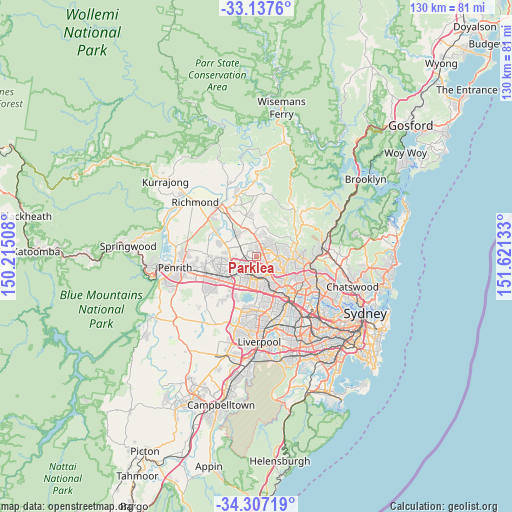
| Upper-left | -33.1376°, | 150.21508° |
| Center: | -33.72439°, | 150.9182° |
| Lower-right: | -34.30719°, | 151.62133° |
| Map W x H: | 130×130 km | = 80.8×80.8mi |
| max Lat: | -10.58257° ⇑49.3% North |
| Parklea: | -33.72439° |
| min Lat: | ⇓50.7% South -43.31423° |
| min Long | Parklea | max Long |
| 113.53327° | 150.9182° | 153.61246° |
| W 66%⇐ | ⇒34% E |
Elevation
Elevation of Parklea is 80 m = 262 ft, and this is 42 m = 138 ft below average elevation for this country.
| Max E: |
1715 m = 5627 ft | 35.1% |
| Avg. | 122 m = 400 ft | |
| Parklea | 80 m = 262 ft | |
Min E: |
-2 m = -7 ft | 64.9% |
See also: Australia elevation on elevation.city.
Geographical zone
Parklea is located in South temperate zone (between Tropic of Capricorn and the Antarctic Circle). Distance of this Southern Tropic circle is 1143.9 km =710.8 mi to North.| Distance of | km | miles | from Parklea |
|---|---|---|---|
| Equator | 3749.8 | 2330 | to North |
| Tropic Capricorn | 1143.9 | 710.8 | to North |
| Antarctic Circle | 3651.4 | 2268.9 | to South |
| South Pole | 6257.3 | 3888.1 | to South |


Nearby cities:
15 places around Parklea: (largest is in red/bold)
• Acacia Gardens
0.8 km =0.5 mi,  191°
191°
• Beaumont Hills
3.4 km =2.1 mi,  37°
37°
• Bella Vista
3.9 km =2.4 mi,  119°
119°
• Blacktown
4.7 km =2.9 mi,  181°
181°
• Glenwood
1.7 km =1.1 mi,  126°
126°
• Kellyville
3.4 km =2.1 mi,  62°
62°
• Kellyville Ridge
2.5 km =1.6 mi,  359°
359°
• Kings Langley
3.3 km =2.1 mi,  150°
150°
• Kings Park
2.3 km =1.4 mi,  205°
205°
• Lalor Park
4.2 km =2.6 mi,  163°
163°
• Marayong
3.5 km =2.2 mi,  221°
221°
• Quakers Hill
3.4 km =2.1 mi,  252°
252°
• Rouse Hill
4.7 km =2.9 mi, 356°
• Stanhope Gardens
0.8 km =0.5 mi,  70°
70°
• The Ponds
2.6 km =1.6 mi,  344°
344°
Sources, notices
• [Note1] Compared only with cities in Australia existing in our database
• [Src1] Map data: © OpenStreetMap contributors (CC-BY-SA)
• [Src2] Other city data from geonames.org with taken over terms of usage.
• [Src3] Geographical zone / Annual Mean Temperature by Robert A. Rohde @ Wikipedia
