Blacktown geodata
Blacktown (New South Wales) is a section of populated place; located in Australia in Australia/Sydney (GMT+11) time zone. With population of 46,942 people, there are 34 cities with bigger population in this country. Compared to other cities in Australia, 50.9% of cities are located further ↑North; 66% of cities are located further ←West and 61.2% of cities have lower elevation than Blacktown. Note1


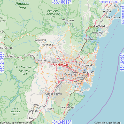
Blacktown GPS coordinates[2]
33° 46' 0.012" South, 150° 55' 0.012" East
| Map corner | latitude | longitude |
|---|---|---|
| Upper-left | -33.18017°, | 150.21355° |
| Center: | -33.76667°, | 150.91667° |
| Lower-right: | -34.34918°, | 151.6198° |
| Map W x H: | 130×130 km | = 80.8×80.8mi |
| max Lat: | -10.58257° ⇑50.9% North |
| Blacktown: | -33.76667° |
| min Lat: | ⇓49.1% South -43.31423° |
| min Long | Blacktown | max Long |
| 113.53327° | 150.91667° | 153.61246° |
| W 66%⇐ | ⇒34% E |
Elevation
Elevation of Blacktown is 67 m = 220 ft, and this is 55 m = 180 ft below average elevation for this country.
| Max E: |
1715 m = 5627 ft | 38.8% |
| Avg. | 122 m = 400 ft | |
| Blacktown | 67 m = 220 ft | |
Min E: |
-2 m = -7 ft | 61.2% |
See also: Blacktown elevation on elevation.city.
Geographical zone
Blacktown is located in South temperate zone (between Tropic of Capricorn and the Antarctic Circle). Distance of this Southern Tropic circle is 1148.6 km =713.7 mi to North.| Distance of | km | miles | from Blacktown |
|---|---|---|---|
| Equator | 3754.5 | 2332.9 | to North |
| Tropic Capricorn | 1148.6 | 713.7 | to North |
| Antarctic Circle | 3646.7 | 2266 | to South |
| South Pole | 6252.6 | 3885.2 | to South |


Nearby cities:
15 places around Blacktown: (largest is in red/bold)
• Acacia Gardens
3.9 km =2.4 mi,  359°
359°
• Bella Vista
4.5 km =2.8 mi,  51°
51°
• Bungarribee
4.6 km =2.9 mi,  255°
255°
• Doonside
4.6 km =2.9 mi,  270°
270°
• Girraween
4.3 km =2.7 mi,  145°
145°
• Glenwood
4 km =2.5 mi,  21°
21°
• Kings Langley
2.5 km =1.6 mi,  43°
43°
• Kings Park
2.7 km =1.7 mi,  342°
342°
• Lalor Park
1.5 km =0.9 mi,  64°
64°
• Marayong
3 km =1.9 mi,  312°
312°
• Parklea
4.7 km =2.9 mi,  1°
1°
• Prospect
3.9 km =2.4 mi,  184°
184°
• Seven Hills
2.4 km =1.5 mi,  140°
140°
• Toongabbie
3.6 km =2.2 mi,  121°
121°
• Woodcroft
3.5 km =2.2 mi,  289°
289°
Sources, notices
• [Note1] Compared only with cities in Australia existing in our database
• [Src1] Map data: © OpenStreetMap contributors (CC-BY-SA)
• [Src2] Other city data from geonames.org with taken over terms of usage.
• [Src3] Geographical zone / Annual Mean Temperature by Robert A. Rohde @ Wikipedia
