Woodcroft geodata
Woodcroft (South Australia) is a section of populated place; located in Australia in Australia/Adelaide (GMT+10.5) time zone. With population of 10,944 people, there are 499 cities with bigger population in this country. Compared to other cities in Australia, 73.1% of cities are located further ↑North; 82.5% of cities are located further →East and 76.5% of cities have lower elevation than Woodcroft. Note1


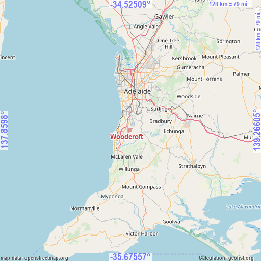
Woodcroft GPS coordinates[2]
35° 6' 8.496" South, 138° 33' 46.512" East
| Map corner | latitude | longitude |
|---|---|---|
| Upper-left | -34.52509°, | 137.8598° |
| Center: | -35.10236°, | 138.56292° |
| Lower-right: | -35.67557°, | 139.26605° |
| Map W x H: | 127.9×127.9 km | = 79.5×79.5mi |
| max Lat: | -10.58257° ⇑73.1% North |
| Woodcroft: | -35.10236° |
| min Lat: | ⇓26.9% South -43.31423° |
| min Long | Woodcroft | max Long |
| 113.53327° | 138.56292° | 153.61246° |
| W 17.5%⇐ | ⇒82.5% E |
Elevation
Elevation of Woodcroft is 142 m = 466 ft, and this is 20 m = 66 ft above average elevation for this country.
| Max E: |
1715 m = 5627 ft | 23.5% |
| Woodcroft | 142 m 466 ft | |
| Avg. | 122 m = 400 ft | |
Min E: |
-2 m = -7 ft | 76.5% |
See also: Australia elevation on elevation.city.
Geographical zone
Woodcroft is located in South temperate zone (between Tropic of Capricorn and the Antarctic Circle). Distance of this Southern Tropic circle is 1297.1 km =806 mi to North.| Distance of | km | miles | from Woodcroft |
|---|---|---|---|
| Equator | 3903 | 2425.2 | to North |
| Tropic Capricorn | 1297.1 | 806 | to North |
| Antarctic Circle | 3498.2 | 2173.7 | to South |
| South Pole | 6104 | 3792.8 | to South |


Nearby cities:
15 places around Woodcroft: (largest is in red/bold)
• Aberfoyle Park
3.9 km =2.4 mi,  42°
42°
• Chandlers Hill
5.2 km =3.2 mi,  70°
70°
• Clarendon
6.6 km =4.1 mi,  103°
103°
• Flagstaff Hill
6.2 km =3.9 mi,  16°
16°
• Hackham West
6.3 km =3.9 mi,  224°
224°
• Hallett Cove
5.1 km =3.2 mi,  300°
300°
• Happy Valley
3.4 km =2.1 mi,  308°
308°
• Morphett Vale
5.4 km =3.4 mi,  230°
230°
• Old Reynella
2.7 km =1.7 mi,  267°
267°
• Onkaparinga Hills
3.7 km =2.3 mi,  174°
174°
• O’Halloran Hill
4.1 km =2.5 mi,  343°
343°
• Reynella
3.1 km =1.9 mi,  288°
288°
• Reynella East
1.3 km =0.8 mi, 336°
• Sheidow Park
4.1 km =2.5 mi, 308°
• Trott Park
3.5 km =2.2 mi,  327°
327°
Sources, notices
• [Note1] Compared only with cities in Australia existing in our database
• [Src1] Map data: © OpenStreetMap contributors (CC-BY-SA)
• [Src2] Other city data from geonames.org with taken over terms of usage.
• [Src3] Geographical zone / Annual Mean Temperature by Robert A. Rohde @ Wikipedia
