Clarendon geodata
Clarendon (South Australia) is a section of populated place; located in Australia in Australia/Adelaide (GMT+10.5) time zone. With population of 597 people, there are 4577 cities with bigger population in this country. Compared to other cities in Australia, 73.2% of cities are located further ↑North; 80.2% of cities are located further →East and 82.9% of cities have lower elevation than Clarendon. Note1


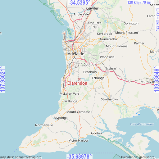
Clarendon GPS coordinates[2]
35° 7' 0.012" South, 138° 37' 59.988" East
| Map corner | latitude | longitude |
|---|---|---|
| Upper-left | -34.5395°, | 137.93021° |
| Center: | -35.11667°, | 138.63333° |
| Lower-right: | -35.68978°, | 139.33646° |
| Map W x H: | 127.9×127.9 km | = 79.5×79.5mi |
| max Lat: | -10.58257° ⇑73.2% North |
| Clarendon: | -35.11667° |
| min Lat: | ⇓26.8% South -43.31423° |
| min Long | Clarendon | max Long |
| 113.53327° | 138.63333° | 153.61246° |
| W 19.8%⇐ | ⇒80.2% E |
Elevation
Elevation of Clarendon is 217 m = 712 ft, and this is 95 m = 312 ft above average elevation for this country.
| Max E: |
1715 m = 5627 ft | 17.1% |
| Clarendon | 217 m 712 ft | |
| Avg. | 122 m = 400 ft | |
Min E: |
-2 m = -7 ft | 82.9% |
See also: Australia elevation on elevation.city.
Geographical zone
Clarendon is located in South temperate zone (between Tropic of Capricorn and the Antarctic Circle). Distance of this Southern Tropic circle is 1298.7 km =807 mi to North.| Distance of | km | miles | from Clarendon |
|---|---|---|---|
| Equator | 3904.6 | 2426.2 | to North |
| Tropic Capricorn | 1298.7 | 807 | to North |
| Antarctic Circle | 3496.6 | 2172.7 | to South |
| South Pole | 6102.5 | 3791.9 | to South |


Nearby cities:
15 places around Clarendon: (largest is in red/bold)
• Aberfoyle Park
5.8 km =3.6 mi,  319°
319°
• Chandlers Hill
3.7 km =2.3 mi,  335°
335°
• Cherry Gardens
6.5 km =4 mi,  24°
24°
• Coromandel Valley
7.6 km =4.7 mi,  348°
348°
• Craigburn Farm
8.9 km =5.5 mi, 343°
• Flagstaff Hill
8.9 km =5.5 mi,  328°
328°
• Ironbank
8.7 km =5.4 mi,  31°
31°
• Kangarilla
4.3 km =2.7 mi,  145°
145°
• Old Reynella
9.2 km =5.7 mi,  279°
279°
• Onkaparinga Hills
6.4 km =4 mi,  251°
251°
• O’Halloran Hill
9.4 km =5.8 mi,  306°
306°
• Reynella
9.7 km =6 mi,  285°
285°
• Reynella East
7.4 km =4.6 mi, 291°
• Trott Park
9.5 km =5.9 mi,  298°
298°
• Woodcroft
6.6 km =4.1 mi, 283°
Sources, notices
• [Note1] Compared only with cities in Australia existing in our database
• [Src1] Map data: © OpenStreetMap contributors (CC-BY-SA)
• [Src2] Other city data from geonames.org with taken over terms of usage.
• [Src3] Geographical zone / Annual Mean Temperature by Robert A. Rohde @ Wikipedia
