Bayview Heights geodata
Bayview Heights (Queensland) is a section of populated place; located in Australia in Australia/Brisbane (GMT+10) time zone. With population of 4,176 people, there are 1726 cities with bigger population in this country. Compared to other cities in Australia, 97% of cities are located further ↓South; 58.4% of cities are located further →East and 66.1% of cities have lower elevation than Bayview Heights. Note1


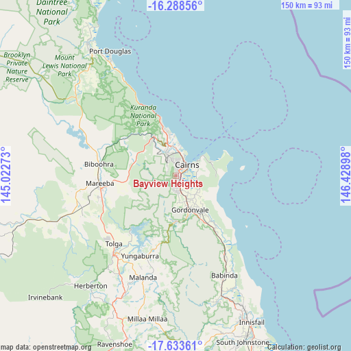
Bayview Heights GPS coordinates[2]
16° 57' 44.244" South, 145° 43' 33.06" East
| Map corner | latitude | longitude |
|---|---|---|
| Upper-left | -16.28856°, | 145.02273° |
| Center: | -16.96229°, | 145.72585° |
| Lower-right: | -17.63361°, | 146.42898° |
| Map W x H: | 149.6×149.6 km | = 93×93mi |
| max Lat: | -10.58257° ⇑3% North |
| Bayview Heights: | -16.96229° |
| min Lat: | ⇓97% South -43.31423° |
| min Long | Bayview Heights | max Long |
| 113.53327° | 145.72585° | 153.61246° |
| W 41.6%⇐ | ⇒58.4% E |
Elevation
Elevation of Bayview Heights is 84 m = 276 ft, and this is 38 m = 125 ft below average elevation for this country.
| Max E: |
1715 m = 5627 ft | 33.9% |
| Avg. | 122 m = 400 ft | |
| Bayview Heights | 84 m = 276 ft | |
Min E: |
-2 m = -7 ft | 66.1% |
See also: Australia elevation on elevation.city.
Geographical zone
Bayview Heights is located in South Torrid zone (between Equator and Tropic of Capricorn). Distance of this Southern Tropic circle is 719.9 km =447.3 mi to South.| Distance of | km | miles | from Bayview Heights |
|---|---|---|---|
| Equator | 1886 | 1171.9 | to North |
| Tropic Capricorn | 719.9 | 447.3 | to South |
| Antarctic Circle | 5515.1 | 3426.9 | to South |
| South Pole | 8121 | 5046.2 | to South |


Nearby cities:
15 places around Bayview Heights: (largest is in red/bold)
• Bentley Park
4.8 km =3 mi,  164°
164°
• Bungalow
4.2 km =2.6 mi,  50°
50°
• Cairns
6.1 km =3.8 mi,  44°
44°
• Earlville
1.5 km =0.9 mi,  30°
30°
• Edmonton
6.6 km =4.1 mi, 162°
• Kanimbla
4.4 km =2.7 mi,  354°
354°
• Manoora
5.2 km =3.2 mi,  12°
12°
• Manunda
5.6 km =3.5 mi, 26°
• Mooroobool
3.1 km =1.9 mi, 10°
• Mount Sheridan
2.7 km =1.7 mi,  165°
165°
• Parramatta Park
5.9 km =3.7 mi, 46°
• Redlynch
5.2 km =3.2 mi,  321°
321°
• Westcourt
4.6 km =2.9 mi, 39°
• White Rock
4.2 km =2.6 mi,  108°
108°
• Woree
2.9 km =1.8 mi,  61°
61°
Sources, notices
• [Note1] Compared only with cities in Australia existing in our database
• [Src1] Map data: © OpenStreetMap contributors (CC-BY-SA)
• [Src2] Other city data from geonames.org with taken over terms of usage.
• [Src3] Geographical zone / Annual Mean Temperature by Robert A. Rohde @ Wikipedia
