Kanimbla geodata
Kanimbla (Queensland) is a section of populated place; located in Australia in Australia/Brisbane (GMT+10) time zone. With population of 2,625 people, there are 2487 cities with bigger population in this country. Compared to other cities in Australia, 97.2% of cities are located further ↓South; 58.4% of cities are located further →East and 53.5% of cities have lower elevation than Kanimbla. Note1


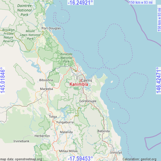
Kanimbla GPS coordinates[2]
16° 55' 23.052" South, 145° 43' 17.688" East
| Map corner | latitude | longitude |
|---|---|---|
| Upper-left | -16.24921°, | 145.01846° |
| Center: | -16.92307°, | 145.72158° |
| Lower-right: | -17.59453°, | 146.42471° |
| Map W x H: | 149.6×149.6 km | = 93×93mi |
| max Lat: | -10.58257° ⇑2.8% North |
| Kanimbla: | -16.92307° |
| min Lat: | ⇓97.2% South -43.31423° |
| min Long | Kanimbla | max Long |
| 113.53327° | 145.72158° | 153.61246° |
| W 41.6%⇐ | ⇒58.4% E |
Elevation
Elevation of Kanimbla is 50 m = 164 ft, and this is 72 m = 236 ft below average elevation for this country.
| Max E: |
1715 m = 5627 ft | 46.5% |
| Avg. | 122 m = 400 ft | |
| Kanimbla | 50 m = 164 ft | |
Min E: |
-2 m = -7 ft | 53.5% |
See also: Australia elevation on elevation.city.
Geographical zone
Kanimbla is located in South Torrid zone (between Equator and Tropic of Capricorn). Distance of this Southern Tropic circle is 724.2 km =450 mi to South.| Distance of | km | miles | from Kanimbla |
|---|---|---|---|
| Equator | 1881.7 | 1169.2 | to North |
| Tropic Capricorn | 724.2 | 450 | to South |
| Antarctic Circle | 5519.5 | 3429.7 | to South |
| South Pole | 8125.4 | 5048.9 | to South |


Nearby cities:
15 places around Kanimbla: (largest is in red/bold)
• Bayview Heights
4.4 km =2.7 mi,  174°
174°
• Brinsmead
2.7 km =1.7 mi,  346°
346°
• Bungalow
4.1 km =2.5 mi,  114°
114°
• Cairns
4.7 km =2.9 mi,  90°
90°
• Cairns North
4.3 km =2.7 mi,  60°
60°
• Earlville
3.3 km =2.1 mi,  158°
158°
• Edge Hill
4 km =2.5 mi,  49°
49°
• Freshwater
4.4 km =2.7 mi, 353°
• Manoora
1.7 km =1.1 mi,  67°
67°
• Manunda
3 km =1.9 mi,  77°
77°
• Mooroobool
1.7 km =1.1 mi,  141°
141°
• Redlynch
2.8 km =1.7 mi,  264°
264°
• Westcourt
3.4 km =2.1 mi,  103°
103°
• Whitfield
3.4 km =2.1 mi,  21°
21°
• Woree
4.3 km =2.7 mi,  134°
134°
Sources, notices
• [Note1] Compared only with cities in Australia existing in our database
• [Src1] Map data: © OpenStreetMap contributors (CC-BY-SA)
• [Src2] Other city data from geonames.org with taken over terms of usage.
• [Src3] Geographical zone / Annual Mean Temperature by Robert A. Rohde @ Wikipedia
