Merewether geodata
Merewether (New South Wales) is a section of populated place; located in Australia in Australia/Sydney (GMT+11) time zone. With population of 10,557 people, there are 534 cities with bigger population in this country. Compared to other cities in Australia, 58% of cities are located further ↓South; 81% of cities are located further ←West and 59% of cities have lower elevation than Merewether. Note1


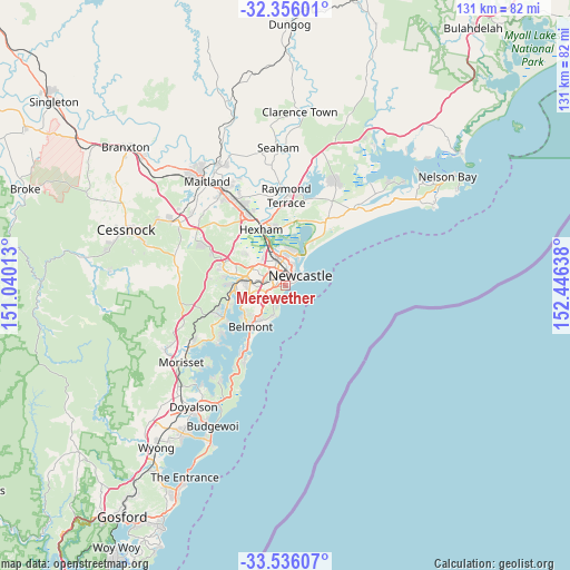
Merewether GPS coordinates[2]
32° 56' 52.836" South, 151° 44' 35.7" East
| Map corner | latitude | longitude |
|---|---|---|
| Upper-left | -32.35601°, | 151.04013° |
| Center: | -32.94801°, | 151.74325° |
| Lower-right: | -33.53607°, | 152.44638° |
| Map W x H: | 131.2×131.2 km | = 81.5×81.5mi |
| max Lat: | -10.58257° ⇑42% North |
| Merewether: | -32.94801° |
| min Lat: | ⇓58% South -43.31423° |
| min Long | Merewether | max Long |
| 113.53327° | 151.74325° | 153.61246° |
| W 81%⇐ | ⇒19% E |
Elevation
Elevation of Merewether is 61 m = 200 ft, and this is 61 m = 200 ft below average elevation for this country.
| Max E: |
1715 m = 5627 ft | 41% |
| Avg. | 122 m = 400 ft | |
| Merewether | 61 m = 200 ft | |
Min E: |
-2 m = -7 ft | 59% |
See also: Australia elevation on elevation.city.
Geographical zone
Merewether is located in South temperate zone (between Tropic of Capricorn and the Antarctic Circle). Distance of this Southern Tropic circle is 1057.6 km =657.2 mi to North.| Distance of | km | miles | from Merewether |
|---|---|---|---|
| Equator | 3663.5 | 2276.4 | to North |
| Tropic Capricorn | 1057.6 | 657.2 | to North |
| Antarctic Circle | 3737.7 | 2322.5 | to South |
| South Pole | 6343.6 | 3941.7 | to South |


Nearby cities:
15 places around Merewether: (largest is in red/bold)
• Adamstown
2 km =1.2 mi,  303°
303°
• Adamstown Heights
3.1 km =1.9 mi,  267°
267°
• Bar Beach
2.2 km =1.4 mi,  70°
70°
• Broadmeadow
3 km =1.9 mi,  332°
332°
• Cooks Hill
3.1 km =1.9 mi,  56°
56°
• Hamilton
2.9 km =1.8 mi,  7°
7°
• Hamilton East
2.6 km =1.6 mi,  21°
21°
• Highfields
2.9 km =1.8 mi,  258°
258°
• Islington
3.8 km =2.4 mi, 5°
• Kahibah
3.2 km =2 mi,  241°
241°
• Merewether Heights
0.7 km =0.4 mi,  276°
276°
• Newcastle West
2.9 km =1.8 mi,  26°
26°
• Newcastle city centre
3.8 km =2.4 mi, 56°
• The Junction
1.8 km =1.1 mi,  53°
53°
• Wickham
3.4 km =2.1 mi, 21°
Sources, notices
• [Note1] Compared only with cities in Australia existing in our database
• [Src1] Map data: © OpenStreetMap contributors (CC-BY-SA)
• [Src2] Other city data from geonames.org with taken over terms of usage.
• [Src3] Geographical zone / Annual Mean Temperature by Robert A. Rohde @ Wikipedia
