Highfields geodata
Highfields (New South Wales) is a section of populated place; located in Australia in Australia/Sydney (GMT+11) time zone. With population of 815 people, there are 4114 cities with bigger population in this country. Compared to other cities in Australia, 58% of cities are located further ↓South; 80.6% of cities are located further ←West and 69.5% of cities have lower elevation than Highfields. Note1


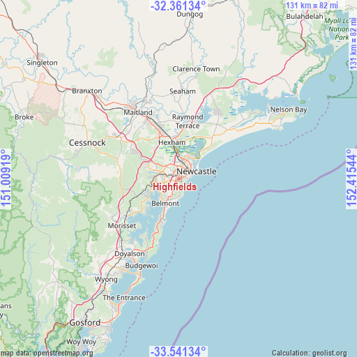
Highfields GPS coordinates[2]
32° 57' 11.916" South, 151° 42' 44.316" East
| Map corner | latitude | longitude |
|---|---|---|
| Upper-left | -32.36134°, | 151.00919° |
| Center: | -32.95331°, | 151.71231° |
| Lower-right: | -33.54134°, | 152.41544° |
| Map W x H: | 131.2×131.2 km | = 81.5×81.5mi |
| max Lat: | -10.58257° ⇑42% North |
| Highfields: | -32.95331° |
| min Lat: | ⇓58% South -43.31423° |
| min Long | Highfields | max Long |
| 113.53327° | 151.71231° | 153.61246° |
| W 80.6%⇐ | ⇒19.4% E |
Elevation
Elevation of Highfields is 100 m = 328 ft, and this is 22 m = 72 ft below average elevation for this country.
| Max E: |
1715 m = 5627 ft | 30.5% |
| Avg. | 122 m = 400 ft | |
| Highfields | 100 m = 328 ft | |
Min E: |
-2 m = -7 ft | 69.5% |
See also: Australia elevation on elevation.city.
Geographical zone
Highfields is located in South temperate zone (between Tropic of Capricorn and the Antarctic Circle). Distance of this Southern Tropic circle is 1058.1 km =657.5 mi to North.| Distance of | km | miles | from Highfields |
|---|---|---|---|
| Equator | 3664.1 | 2276.8 | to North |
| Tropic Capricorn | 1058.1 | 657.5 | to North |
| Antarctic Circle | 3737.1 | 2322.1 | to South |
| South Pole | 6343 | 3941.4 | to South |


Nearby cities:
15 places around Highfields: (largest is in red/bold)
• Adamstown
2.1 km =1.3 mi,  36°
36°
• Adamstown Heights
0.5 km =0.3 mi,  336°
336°
• Broadmeadow
3.6 km =2.2 mi,  24°
24°
• Charlestown
2.4 km =1.5 mi,  226°
226°
• Garden Suburb
3.1 km =1.9 mi,  290°
290°
• Gateshead
3.7 km =2.3 mi,  210°
210°
• Hillsborough
4 km =2.5 mi,  249°
249°
• Kahibah
0.9 km =0.6 mi,  178°
178°
• Kotara
1.9 km =1.2 mi,  307°
307°
• Kotara South
2 km =1.2 mi,  272°
272°
• Merewether
2.9 km =1.8 mi,  78°
78°
• Merewether Heights
2.3 km =1.4 mi,  73°
73°
• New Lambton
2.8 km =1.7 mi,  352°
352°
• New Lambton Heights
3.6 km =2.2 mi,  331°
331°
• Whitebridge
2.4 km =1.5 mi,  171°
171°
Sources, notices
• [Note1] Compared only with cities in Australia existing in our database
• [Src1] Map data: © OpenStreetMap contributors (CC-BY-SA)
• [Src2] Other city data from geonames.org with taken over terms of usage.
• [Src3] Geographical zone / Annual Mean Temperature by Robert A. Rohde @ Wikipedia
