Glenunga geodata
Glenunga (South Australia) is a section of populated place; located in Australia in Australia/Adelaide (GMT+10.5) time zone. With population of 2,006 people, there are 2904 cities with bigger population in this country. Compared to other cities in Australia, 69.9% of cities are located further ↑North; 79.9% of cities are located further →East and 67.8% of cities have lower elevation than Glenunga. Note1


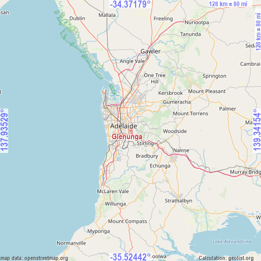
Glenunga GPS coordinates[2]
34° 57' 0.468" South, 138° 38' 18.276" East
| Map corner | latitude | longitude |
|---|---|---|
| Upper-left | -34.37179°, | 137.93529° |
| Center: | -34.95013°, | 138.63841° |
| Lower-right: | -35.52442°, | 139.34154° |
| Map W x H: | 128.2×128.2 km | = 79.7×79.7mi |
| max Lat: | -10.58257° ⇑69.9% North |
| Glenunga: | -34.95013° |
| min Lat: | ⇓30.1% South -43.31423° |
| min Long | Glenunga | max Long |
| 113.53327° | 138.63841° | 153.61246° |
| W 20.1%⇐ | ⇒79.9% E |
Elevation
Elevation of Glenunga is 92 m = 302 ft, and this is 30 m = 98 ft below average elevation for this country.
| Max E: |
1715 m = 5627 ft | 32.2% |
| Avg. | 122 m = 400 ft | |
| Glenunga | 92 m = 302 ft | |
Min E: |
-2 m = -7 ft | 67.8% |
See also: Australia elevation on elevation.city.
Geographical zone
Glenunga is located in South temperate zone (between Tropic of Capricorn and the Antarctic Circle). Distance of this Southern Tropic circle is 1280.2 km =795.5 mi to North.| Distance of | km | miles | from Glenunga |
|---|---|---|---|
| Equator | 3886.1 | 2414.7 | to North |
| Tropic Capricorn | 1280.2 | 795.5 | to North |
| Antarctic Circle | 3515.1 | 2184.2 | to South |
| South Pole | 6121 | 3803.4 | to South |


Nearby cities:
15 places around Glenunga: (largest is in red/bold)
• Beaumont
2.1 km =1.3 mi,  86°
86°
• Dulwich
1.8 km =1.1 mi,  326°
326°
• Eastwood
1.7 km =1.1 mi,  299°
299°
• Frewville
0.8 km =0.5 mi,  291°
291°
• Fullarton
0.9 km =0.6 mi,  263°
263°
• Glen Osmond
1.4 km =0.9 mi,  138°
138°
• Glenside
0.9 km =0.6 mi, 332°
• Heathpool
2.2 km =1.4 mi,  19°
19°
• Highgate
2 km =1.2 mi,  229°
229°
• Linden Park
1.1 km =0.7 mi,  47°
47°
• Myrtle Bank
1.2 km =0.7 mi,  200°
200°
• St Georges
0.9 km =0.6 mi,  103°
103°
• Toorak Gardens
1.7 km =1.1 mi,  353°
353°
• Tusmore
1.7 km =1.1 mi,  41°
41°
• Urrbrae
1.8 km =1.1 mi,  169°
169°
Sources, notices
• [Note1] Compared only with cities in Australia existing in our database
• [Src1] Map data: © OpenStreetMap contributors (CC-BY-SA)
• [Src2] Other city data from geonames.org with taken over terms of usage.
• [Src3] Geographical zone / Annual Mean Temperature by Robert A. Rohde @ Wikipedia
