Fadden geodata
Fadden (ACT) is a section of populated place; located in Australia in Australia/Sydney (GMT+11) time zone. With population of 2,847 people, there are 2350 cities with bigger population in this country. Compared to other cities in Australia, 76.6% of cities are located further ↑North; 54.2% of cities are located further ←West and 97.3% of cities have lower elevation than Fadden. Note1


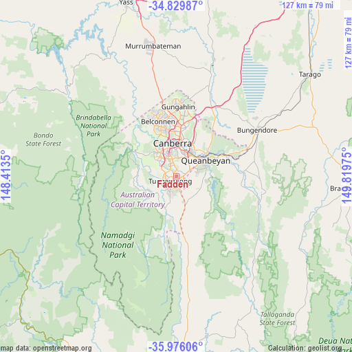
Fadden GPS coordinates[2]
35° 24' 18" South, 149° 6' 59.832" East
| Map corner | latitude | longitude |
|---|---|---|
| Upper-left | -34.82987°, | 148.4135° |
| Center: | -35.405°, | 149.11662° |
| Lower-right: | -35.97606°, | 149.81975° |
| Map W x H: | 127.4×127.4 km | = 79.2×79.2mi |
| max Lat: | -10.58257° ⇑76.6% North |
| Fadden: | -35.405° |
| min Lat: | ⇓23.4% South -43.31423° |
| min Long | Fadden | max Long |
| 113.53327° | 149.11662° | 153.61246° |
| W 54.2%⇐ | ⇒45.8% E |
Elevation
Elevation of Fadden is 642 m = 2106 ft, and this is 520 m = 1706 ft above average elevation for this country.
| Max E: |
1715 m = 5627 ft | 2.7% |
| Fadden | 642 m 2106 ft | |
| Avg. | 122 m = 400 ft | |
Min E: |
-2 m = -7 ft | 97.3% |
See also: Australia elevation on elevation.city.
Geographical zone
Fadden is located in South temperate zone (between Tropic of Capricorn and the Antarctic Circle). Distance of this Southern Tropic circle is 1330.7 km =826.9 mi to North.| Distance of | km | miles | from Fadden |
|---|---|---|---|
| Equator | 3936.7 | 2446.2 | to North |
| Tropic Capricorn | 1330.7 | 826.9 | to North |
| Antarctic Circle | 3464.5 | 2152.7 | to South |
| South Pole | 6070.4 | 3772 | to South |


Nearby cities:
15 places around Fadden: (largest is in red/bold)
• Bonython
4.7 km =2.9 mi,  227°
227°
• Calwell
4 km =2.5 mi,  192°
192°
• Chisholm
1.3 km =0.8 mi,  128°
128°
• Farrer
3.3 km =2.1 mi,  341°
341°
• Gilmore
2.3 km =1.4 mi,  135°
135°
• Gowrie
1 km =0.6 mi,  222°
222°
• Greenway
4.8 km =3 mi,  251°
251°
• Isaacs
4 km =2.5 mi,  358°
358°
• Isabella Plains
3.7 km =2.3 mi, 225°
• Macarthur
1 km =0.6 mi,  114°
114°
• Monash
2.6 km =1.6 mi,  243°
243°
• Oxley
3.5 km =2.2 mi,  261°
261°
• Richardson
2.6 km =1.6 mi, 185°
• Torrens
4.5 km =2.8 mi,  324°
324°
• Wanniassa
2.5 km =1.6 mi,  288°
288°
Sources, notices
• [Note1] Compared only with cities in Australia existing in our database
• [Src1] Map data: © OpenStreetMap contributors (CC-BY-SA)
• [Src2] Other city data from geonames.org with taken over terms of usage.
• [Src3] Geographical zone / Annual Mean Temperature by Robert A. Rohde @ Wikipedia
