Isaacs geodata
Isaacs (ACT) is a section of populated place; located in Australia in Australia/Sydney (GMT+11) time zone. With population of 2,265 people, there are 2719 cities with bigger population in this country. Compared to other cities in Australia, 76.3% of cities are located further ↑North; 54.2% of cities are located further ←West and 98.3% of cities have lower elevation than Isaacs. Note1


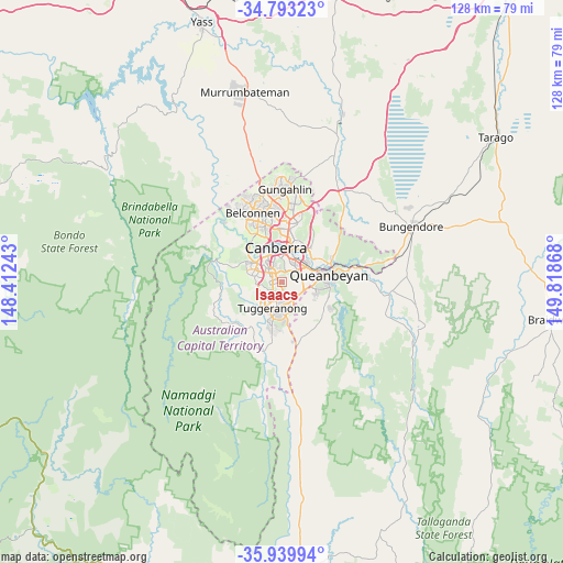
Isaacs GPS coordinates[2]
35° 22' 7.032" South, 149° 6' 55.98" East
| Map corner | latitude | longitude |
|---|---|---|
| Upper-left | -34.79323°, | 148.41243° |
| Center: | -35.36862°, | 149.11555° |
| Lower-right: | -35.93994°, | 149.81868° |
| Map W x H: | 127.5×127.5 km | = 79.2×79.2mi |
| max Lat: | -10.58257° ⇑76.3% North |
| Isaacs: | -35.36862° |
| min Lat: | ⇓23.7% South -43.31423° |
| min Long | Isaacs | max Long |
| 113.53327° | 149.11555° | 153.61246° |
| W 54.2%⇐ | ⇒45.8% E |
Elevation
Elevation of Isaacs is 686 m = 2251 ft, and this is 564 m = 1850 ft above average elevation for this country.
| Max E: |
1715 m = 5627 ft | 1.7% |
| Isaacs | 686 m 2251 ft | |
| Avg. | 122 m = 400 ft | |
Min E: |
-2 m = -7 ft | 98.3% |
See also: Australia elevation on elevation.city.
Geographical zone
Isaacs is located in South temperate zone (between Tropic of Capricorn and the Antarctic Circle). Distance of this Southern Tropic circle is 1326.7 km =824.4 mi to North.| Distance of | km | miles | from Isaacs |
|---|---|---|---|
| Equator | 3932.6 | 2443.6 | to North |
| Tropic Capricorn | 1326.7 | 824.4 | to North |
| Antarctic Circle | 3468.6 | 2155.3 | to South |
| South Pole | 6074.4 | 3774.5 | to South |


Nearby cities:
15 places around Isaacs: (largest is in red/bold)
• Chifley
3.9 km =2.4 mi,  295°
295°
• Fadden
4 km =2.5 mi,  178°
178°
• Farrer
1.3 km =0.8 mi,  226°
226°
• Garran
3 km =1.9 mi,  347°
347°
• Hughes
4.4 km =2.7 mi,  334°
334°
• Macarthur
4.6 km =2.9 mi,  166°
166°
• Mawson
1.6 km =1 mi,  290°
290°
• Narrabundah
4.8 km =3 mi,  39°
39°
• O'Malley
1.8 km =1.1 mi, 352°
• Pearce
3 km =1.9 mi,  283°
283°
• Phillip
3 km =1.9 mi,  312°
312°
• Red Hill
4.7 km =2.9 mi,  3°
3°
• Symonston
4.4 km =2.7 mi,  64°
64°
• Torrens
2.6 km =1.6 mi,  261°
261°
• Wanniassa
3.9 km =2.4 mi,  214°
214°
Sources, notices
• [Note1] Compared only with cities in Australia existing in our database
• [Src1] Map data: © OpenStreetMap contributors (CC-BY-SA)
• [Src2] Other city data from geonames.org with taken over terms of usage.
• [Src3] Geographical zone / Annual Mean Temperature by Robert A. Rohde @ Wikipedia
