Bowden geodata
Bowden (South Australia) is a section of populated place; located in Australia in Australia/Adelaide (GMT+10.5) time zone. With population of 903 people, there are 3969 cities with bigger population in this country. Compared to other cities in Australia, 68.3% of cities are located further ↑North; 82.1% of cities are located further →East and 69.8% of cities have higher elevation than Bowden. Note1


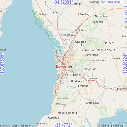
Bowden GPS coordinates[2]
34° 54' 9.288" South, 138° 34' 44.796" East
| Map corner | latitude | longitude |
|---|---|---|
| Upper-left | -34.32391°, | 137.87599° |
| Center: | -34.90258°, | 138.57911° |
| Lower-right: | -35.4772°, | 139.28224° |
| Map W x H: | 128.2×128.2 km | = 79.7×79.7mi |
| max Lat: | -10.58257° ⇑68.3% North |
| Bowden: | -34.90258° |
| min Lat: | ⇓31.7% South -43.31423° |
| min Long | Bowden | max Long |
| 113.53327° | 138.57911° | 153.61246° |
| W 17.9%⇐ | ⇒82.1% E |
Elevation
Elevation of Bowden is 23 m = 75 ft, and this is 99 m = 325 ft below average elevation for this country.
| Max E: |
1715 m = 5627 ft | 69.8% |
| Avg. | 122 m = 400 ft | |
| Bowden | 23 m = 75 ft | |
Min E: |
-2 m = -7 ft | 30.2% |
See also: Australia elevation on elevation.city.
Geographical zone
Bowden is located in South temperate zone (between Tropic of Capricorn and the Antarctic Circle). Distance of this Southern Tropic circle is 1274.9 km =792.2 mi to North.| Distance of | km | miles | from Bowden |
|---|---|---|---|
| Equator | 3880.8 | 2411.4 | to North |
| Tropic Capricorn | 1274.9 | 792.2 | to North |
| Antarctic Circle | 3520.4 | 2187.5 | to South |
| South Pole | 6126.3 | 3806.7 | to South |


Nearby cities:
15 places around Bowden: (largest is in red/bold)
• Allenby Gardens
2.3 km =1.4 mi,  283°
283°
• Brompton
0.9 km =0.6 mi,  354°
354°
• Devon Park
1.8 km =1.1 mi,  9°
9°
• Fitzroy
1.3 km =0.8 mi,  60°
60°
• Medindie
2.5 km =1.6 mi,  72°
72°
• North Adelaide
1.2 km =0.7 mi,  115°
115°
• Ovingham
0.7 km =0.4 mi,  51°
51°
• Prospect
2.6 km =1.6 mi,  29°
29°
• Renown Park
1.2 km =0.7 mi, 352°
• Ridleyton
1.3 km =0.8 mi,  327°
327°
• Thebarton
1.9 km =1.2 mi,  215°
215°
• Torrensville
2.6 km =1.6 mi, 218°
• Welland
1.9 km =1.2 mi,  266°
266°
• West Croydon
2 km =1.2 mi,  296°
296°
• West Hindmarsh
1.5 km =0.9 mi,  246°
246°
Sources, notices
• [Note1] Compared only with cities in Australia existing in our database
• [Src1] Map data: © OpenStreetMap contributors (CC-BY-SA)
• [Src2] Other city data from geonames.org with taken over terms of usage.
• [Src3] Geographical zone / Annual Mean Temperature by Robert A. Rohde @ Wikipedia
