Brompton geodata
Brompton (South Australia) is a section of populated place; located in Australia in Australia/Adelaide (GMT+10.5) time zone. With population of 3,434 people, there are 2014 cities with bigger population in this country. Compared to other cities in Australia, 67.9% of cities are located further ↑North; 82.1% of cities are located further →East and 76.1% of cities have higher elevation than Brompton. Note1


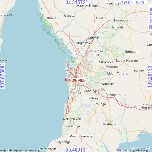
Brompton GPS coordinates[2]
34° 53' 40.02" South, 138° 34' 41.52" East
| Map corner | latitude | longitude |
|---|---|---|
| Upper-left | -34.31572°, | 137.87508° |
| Center: | -34.89445°, | 138.5782° |
| Lower-right: | -35.46913°, | 139.28133° |
| Map W x H: | 128.2×128.2 km | = 79.7×79.7mi |
| max Lat: | -10.58257° ⇑67.9% North |
| Brompton: | -34.89445° |
| min Lat: | ⇓32.1% South -43.31423° |
| min Long | Brompton | max Long |
| 113.53327° | 138.5782° | 153.61246° |
| W 17.9%⇐ | ⇒82.1% E |
Elevation
Elevation of Brompton is 18 m = 59 ft, and this is 104 m = 341 ft below average elevation for this country.
| Max E: |
1715 m = 5627 ft | 76.1% |
| Avg. | 122 m = 400 ft | |
| Brompton | 18 m = 59 ft | |
Min E: |
-2 m = -7 ft | 23.9% |
See also: Australia elevation on elevation.city.
Geographical zone
Brompton is located in South temperate zone (between Tropic of Capricorn and the Antarctic Circle). Distance of this Southern Tropic circle is 1274 km =791.6 mi to North.| Distance of | km | miles | from Brompton |
|---|---|---|---|
| Equator | 3879.9 | 2410.9 | to North |
| Tropic Capricorn | 1274 | 791.6 | to North |
| Antarctic Circle | 3521.3 | 2188 | to South |
| South Pole | 6127.2 | 3807.3 | to South |


Nearby cities:
15 places around Brompton: (largest is in red/bold)
• Allenby Gardens
2.2 km =1.4 mi,  260°
260°
• Bowden
0.9 km =0.6 mi,  174°
174°
• Croydon Park
1.8 km =1.1 mi,  328°
328°
• Devon Park
1 km =0.6 mi,  22°
22°
• Dudley Park
2.1 km =1.3 mi,  357°
357°
• Fitzroy
1.2 km =0.7 mi,  102°
102°
• Medindie
2.5 km =1.6 mi,  94°
94°
• North Adelaide
1.9 km =1.2 mi,  139°
139°
• Ovingham
0.8 km =0.5 mi,  126°
126°
• Prospect
1.9 km =1.2 mi,  45°
45°
• Renown Park
0.3 km =0.2 mi,  344°
344°
• Ridleyton
0.6 km =0.4 mi,  286°
286°
• Welland
2.1 km =1.3 mi,  240°
240°
• West Croydon
1.7 km =1.1 mi,  269°
269°
• West Hindmarsh
2 km =1.2 mi,  220°
220°
Sources, notices
• [Note1] Compared only with cities in Australia existing in our database
• [Src1] Map data: © OpenStreetMap contributors (CC-BY-SA)
• [Src2] Other city data from geonames.org with taken over terms of usage.
• [Src3] Geographical zone / Annual Mean Temperature by Robert A. Rohde @ Wikipedia
