Ridleyton geodata
Ridleyton (South Australia) is a section of populated place; located in Australia in Australia/Adelaide (GMT+10.5) time zone. With population of 1,111 people, there are 3686 cities with bigger population in this country. Compared to other cities in Australia, 67.9% of cities are located further ↑North; 82.3% of cities are located further →East and 77.5% of cities have higher elevation than Ridleyton. Note1


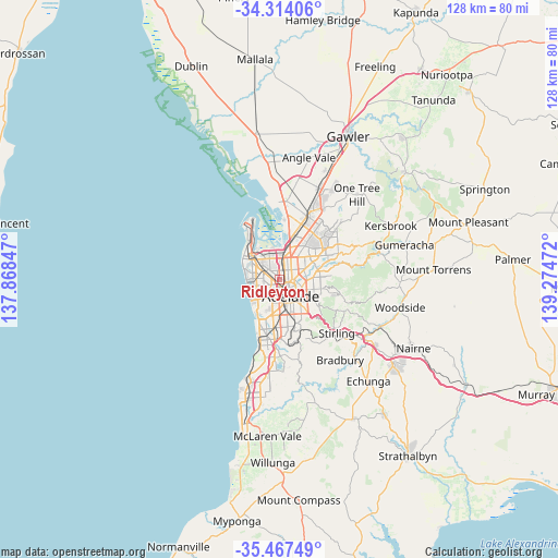
Ridleyton GPS coordinates[2]
34° 53' 34.08" South, 138° 34' 17.724" East
| Map corner | latitude | longitude |
|---|---|---|
| Upper-left | -34.31406°, | 137.86847° |
| Center: | -34.8928°, | 138.57159° |
| Lower-right: | -35.46749°, | 139.27472° |
| Map W x H: | 128.2×128.2 km | = 79.7×79.7mi |
| max Lat: | -10.58257° ⇑67.9% North |
| Ridleyton: | -34.8928° |
| min Lat: | ⇓32.1% South -43.31423° |
| min Long | Ridleyton | max Long |
| 113.53327° | 138.57159° | 153.61246° |
| W 17.7%⇐ | ⇒82.3% E |
Elevation
Elevation of Ridleyton is 17 m = 56 ft, and this is 105 m = 344 ft below average elevation for this country.
| Max E: |
1715 m = 5627 ft | 77.5% |
| Avg. | 122 m = 400 ft | |
| Ridleyton | 17 m = 56 ft | |
Min E: |
-2 m = -7 ft | 22.5% |
See also: Australia elevation on elevation.city.
Geographical zone
Ridleyton is located in South temperate zone (between Tropic of Capricorn and the Antarctic Circle). Distance of this Southern Tropic circle is 1273.8 km =791.5 mi to North.| Distance of | km | miles | from Ridleyton |
|---|---|---|---|
| Equator | 3879.7 | 2410.7 | to North |
| Tropic Capricorn | 1273.8 | 791.5 | to North |
| Antarctic Circle | 3521.5 | 2188.2 | to South |
| South Pole | 6127.3 | 3807.3 | to South |


Nearby cities:
15 places around Ridleyton: (largest is in red/bold)
• Allenby Gardens
1.7 km =1.1 mi,  251°
251°
• Beverley
2.3 km =1.4 mi,  263°
263°
• Bowden
1.3 km =0.8 mi,  147°
147°
• Brompton
0.6 km =0.4 mi,  106°
106°
• Croydon Park
1.4 km =0.9 mi,  346°
346°
• Devon Park
1.2 km =0.7 mi,  54°
54°
• Dudley Park
2 km =1.2 mi,  15°
15°
• Fitzroy
1.9 km =1.2 mi,  103°
103°
• Kilkenny
2.3 km =1.4 mi,  311°
311°
• Ovingham
1.4 km =0.9 mi,  117°
117°
• Prospect
2.3 km =1.4 mi,  59°
59°
• Renown Park
0.5 km =0.3 mi,  77°
77°
• Welland
1.7 km =1.1 mi,  224°
224°
• West Croydon
1.1 km =0.7 mi, 260°
• West Hindmarsh
1.8 km =1.1 mi,  202°
202°
Sources, notices
• [Note1] Compared only with cities in Australia existing in our database
• [Src1] Map data: © OpenStreetMap contributors (CC-BY-SA)
• [Src2] Other city data from geonames.org with taken over terms of usage.
• [Src3] Geographical zone / Annual Mean Temperature by Robert A. Rohde @ Wikipedia
