Helena Valley geodata
Helena Valley (Western Australia) is a section of populated place; located in Australia in Australia/Perth (GMT+8) time zone. With population of 3,578 people, there are 1965 cities with bigger population in this country. Compared to other cities in Australia, 66.2% of cities are located further ↓South; 91.9% of cities are located further →East and 79% of cities have higher elevation than Helena Valley. Note1


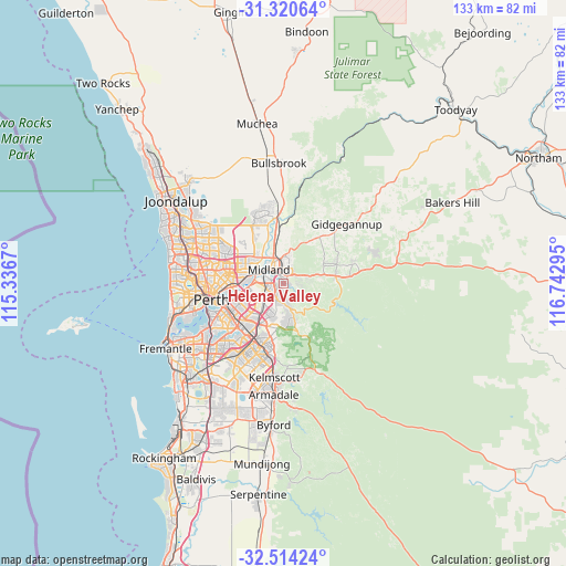
Helena Valley GPS coordinates[2]
31° 55' 9.768" South, 116° 2' 23.352" East
| Map corner | latitude | longitude |
|---|---|---|
| Upper-left | -31.32064°, | 115.3367° |
| Center: | -31.91938°, | 116.03982° |
| Lower-right: | -32.51424°, | 116.74295° |
| Map W x H: | 132.7×132.7 km | = 82.5×82.5mi |
| max Lat: | -10.58257° ⇑33.8% North |
| Helena Valley: | -31.91938° |
| min Lat: | ⇓66.2% South -43.31423° |
| min Long | Helena Valley | max Long |
| 113.53327° | 116.03982° | 153.61246° |
| W 8.1%⇐ | ⇒91.9% E |
Elevation
Elevation of Helena Valley is 16 m = 52 ft, and this is 106 m = 348 ft below average elevation for this country.
| Max E: |
1715 m = 5627 ft | 79% |
| Avg. | 122 m = 400 ft | |
| Helena Valley | 16 m = 52 ft | |
Min E: |
-2 m = -7 ft | 21% |
See also: Australia elevation on elevation.city.
Geographical zone
Helena Valley is located in South temperate zone (between Tropic of Capricorn and the Antarctic Circle). Distance of this Southern Tropic circle is 943.2 km =586.1 mi to North.| Distance of | km | miles | from Helena Valley |
|---|---|---|---|
| Equator | 3549.1 | 2205.3 | to North |
| Tropic Capricorn | 943.2 | 586.1 | to North |
| Antarctic Circle | 3852.1 | 2393.6 | to South |
| South Pole | 6458 | 4012.8 | to South |


Nearby cities:
15 places around Helena Valley: (largest is in red/bold)
• Bellevue
2.3 km =1.4 mi,  330°
330°
• Boya
1.7 km =1.1 mi,  89°
89°
• Darlington
3.9 km =2.4 mi, 89°
• Gooseberry Hill
4 km =2.5 mi,  167°
167°
• Greenmount
2.3 km =1.4 mi,  23°
23°
• Hazelmere
2.7 km =1.7 mi,  274°
274°
• High Wycombe
4.4 km =2.7 mi,  230°
230°
• Koongamia
1.4 km =0.9 mi,  9°
9°
• Maida Vale
3.8 km =2.4 mi,  197°
197°
• Midland
4.3 km =2.7 mi,  320°
320°
• Midvale
3.5 km =2.2 mi,  349°
349°
• Stratton
5.7 km =3.5 mi,  0°
0°
• Swan View
4.1 km =2.5 mi, 13°
• Viveash
6.1 km =3.8 mi, 318°
• Woodbridge
5.8 km =3.6 mi,  308°
308°
Sources, notices
• [Note1] Compared only with cities in Australia existing in our database
• [Src1] Map data: © OpenStreetMap contributors (CC-BY-SA)
• [Src2] Other city data from geonames.org with taken over terms of usage.
• [Src3] Geographical zone / Annual Mean Temperature by Robert A. Rohde @ Wikipedia
