Karloo geodata
Karloo (Western Australia) is a section of populated place; located in Australia in Australia/Perth (GMT+8) time zone. With population of 575 people, there are 4631 cities with bigger population in this country. Compared to other cities in Australia, 73.7% of cities are located further ↓South; 99.4% of cities are located further →East and 69.8% of cities have higher elevation than Karloo. Note1


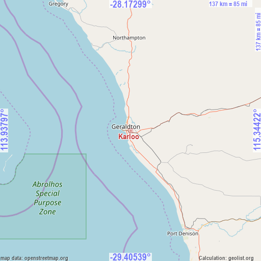
Karloo GPS coordinates[2]
28° 47' 27.636" South, 114° 38' 27.924" East
| Map corner | latitude | longitude |
|---|---|---|
| Upper-left | -28.17299°, | 113.93797° |
| Center: | -28.79101°, | 114.64109° |
| Lower-right: | -29.40539°, | 115.34422° |
| Map W x H: | 137×137 km | = 85.1×85.1mi |
| max Lat: | -10.58257° ⇑26.3% North |
| Karloo: | -28.79101° |
| min Lat: | ⇓73.7% South -43.31423° |
| min Long | Karloo | max Long |
| 113.53327° | 114.64109° | 153.61246° |
| W 0.6%⇐ | ⇒99.4% E |
Elevation
Elevation of Karloo is 23 m = 75 ft, and this is 99 m = 325 ft below average elevation for this country.
| Max E: |
1715 m = 5627 ft | 69.8% |
| Avg. | 122 m = 400 ft | |
| Karloo | 23 m = 75 ft | |
Min E: |
-2 m = -7 ft | 30.2% |
See also: Australia elevation on elevation.city.
Geographical zone
Karloo is located in South temperate zone (between Tropic of Capricorn and the Antarctic Circle). Distance of this Southern Tropic circle is 595.3 km =369.9 mi to North.| Distance of | km | miles | from Karloo |
|---|---|---|---|
| Equator | 3201.3 | 1989.2 | to North |
| Tropic Capricorn | 595.3 | 369.9 | to North |
| Antarctic Circle | 4199.9 | 2609.7 | to South |
| South Pole | 6805.8 | 4228.9 | to South |


Nearby cities:
15 places around Karloo: (largest is in red/bold)
• Beachlands
3.9 km =2.4 mi,  278°
278°
• Beresford
4.3 km =2.7 mi,  330°
330°
• Deepdale
5.3 km =3.3 mi,  84°
84°
• Geraldton
2.9 km =1.8 mi,  297°
297°
• Geraldton city centre
3 km =1.9 mi, 300°
• Mahomets Flats
2.7 km =1.7 mi,  267°
267°
• Mount Tarcoola
1.8 km =1.1 mi,  241°
241°
• Rangeway
1.1 km =0.7 mi, 295°
• Strathalbyn
4.4 km =2.7 mi,  5°
5°
• Tarcoola Beach
2.8 km =1.7 mi,  220°
220°
• Utakarra
1.2 km =0.7 mi,  45°
45°
• Wandina
3.2 km =2 mi,  191°
191°
• West End
6.1 km =3.8 mi, 279°
• Wonthella
2.8 km =1.7 mi,  344°
344°
• Woorree
3.2 km =2 mi,  31°
31°
Sources, notices
• [Note1] Compared only with cities in Australia existing in our database
• [Src1] Map data: © OpenStreetMap contributors (CC-BY-SA)
• [Src2] Other city data from geonames.org with taken over terms of usage.
• [Src3] Geographical zone / Annual Mean Temperature by Robert A. Rohde @ Wikipedia
