Strathalbyn geodata
Strathalbyn (Western Australia) is a section of populated place; located in Australia in Australia/Perth (GMT+8) time zone. With population of 1,193 people, there are 3593 cities with bigger population in this country. Compared to other cities in Australia, 74% of cities are located further ↓South; 99.4% of cities are located further →East and 64.8% of cities have higher elevation than Strathalbyn. Note1


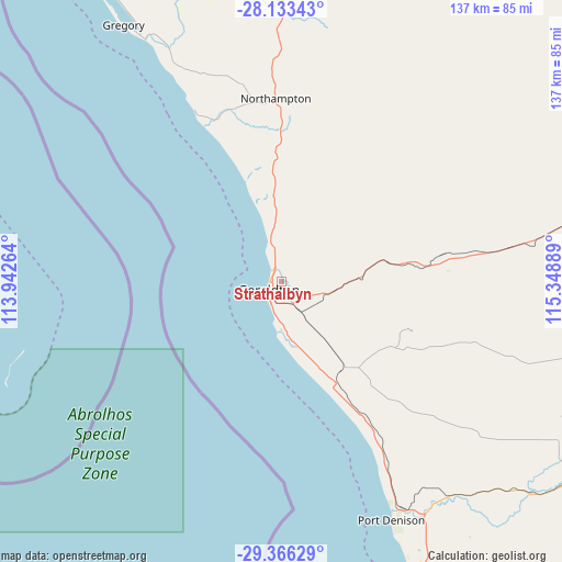
Strathalbyn GPS coordinates[2]
28° 45' 6.048" South, 114° 38' 44.736" East
| Map corner | latitude | longitude |
|---|---|---|
| Upper-left | -28.13343°, | 113.94264° |
| Center: | -28.75168°, | 114.64576° |
| Lower-right: | -29.36629°, | 115.34889° |
| Map W x H: | 137.1×137.1 km | = 85.2×85.2mi |
| max Lat: | -10.58257° ⇑26% North |
| Strathalbyn: | -28.75168° |
| min Lat: | ⇓74% South -43.31423° |
| min Long | Strathalbyn | max Long |
| 113.53327° | 114.64576° | 153.61246° |
| W 0.6%⇐ | ⇒99.4% E |
Elevation
Elevation of Strathalbyn is 27 m = 89 ft, and this is 95 m = 312 ft below average elevation for this country.
| Max E: |
1715 m = 5627 ft | 64.8% |
| Avg. | 122 m = 400 ft | |
| Strathalbyn | 27 m = 89 ft | |
Min E: |
-2 m = -7 ft | 35.2% |
See also: Australia elevation on elevation.city.
Geographical zone
Strathalbyn is located in South temperate zone (between Tropic of Capricorn and the Antarctic Circle). Distance of this Southern Tropic circle is 591 km =367.2 mi to North.| Distance of | km | miles | from Strathalbyn |
|---|---|---|---|
| Equator | 3196.9 | 1986.5 | to North |
| Tropic Capricorn | 591 | 367.2 | to North |
| Antarctic Circle | 4204.3 | 2612.4 | to South |
| South Pole | 6810.2 | 4231.7 | to South |


Nearby cities:
15 places around Strathalbyn: (largest is in red/bold)
• Beresford
2.6 km =1.6 mi,  255°
255°
• Bluff Point
2.7 km =1.7 mi,  305°
305°
• Geraldton
4.3 km =2.7 mi,  225°
225°
• Geraldton city centre
4.2 km =2.6 mi, 226°
• Karloo
4.4 km =2.7 mi,  185°
185°
• Mahomets Flats
5.5 km =3.4 mi,  215°
215°
• Moresby
3.2 km =2 mi,  54°
54°
• Mount Tarcoola
5.6 km =3.5 mi,  200°
200°
• Rangeway
4.2 km =2.6 mi, 200°
• Spalding
2 km =1.2 mi,  333°
333°
• Sunset Beach
4.3 km =2.7 mi, 328°
• Utakarra
3.5 km =2.2 mi,  173°
173°
• Waggrakine
3.7 km =2.3 mi,  350°
350°
• Wonthella
2.1 km =1.3 mi, 215°
• Woorree
2.1 km =1.3 mi,  144°
144°
Sources, notices
• [Note1] Compared only with cities in Australia existing in our database
• [Src1] Map data: © OpenStreetMap contributors (CC-BY-SA)
• [Src2] Other city data from geonames.org with taken over terms of usage.
• [Src3] Geographical zone / Annual Mean Temperature by Robert A. Rohde @ Wikipedia
