Woorree geodata
Woorree (Western Australia) is a section of populated place; located in Australia in Australia/Perth (GMT+8) time zone. With population of 1,282 people, there are 3487 cities with bigger population in this country. Compared to other cities in Australia, 73.9% of cities are located further ↓South; 99.3% of cities are located further →East and 62.8% of cities have higher elevation than Woorree. Note1


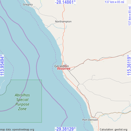
Woorree GPS coordinates[2]
28° 46' 0.372" South, 114° 39' 29.016" East
| Map corner | latitude | longitude |
|---|---|---|
| Upper-left | -28.14861°, | 113.95494° |
| Center: | -28.76677°, | 114.65806° |
| Lower-right: | -29.38129°, | 115.36119° |
| Map W x H: | 137.1×137.1 km | = 85.2×85.2mi |
| max Lat: | -10.58257° ⇑26.1% North |
| Woorree: | -28.76677° |
| min Lat: | ⇓73.9% South -43.31423° |
| min Long | Woorree | max Long |
| 113.53327° | 114.65806° | 153.61246° |
| W 0.7%⇐ | ⇒99.3% E |
Elevation
Elevation of Woorree is 29 m = 95 ft, and this is 93 m = 305 ft below average elevation for this country.
| Max E: |
1715 m = 5627 ft | 62.8% |
| Avg. | 122 m = 400 ft | |
| Woorree | 29 m = 95 ft | |
Min E: |
-2 m = -7 ft | 37.2% |
See also: Australia elevation on elevation.city.
Geographical zone
Woorree is located in South temperate zone (between Tropic of Capricorn and the Antarctic Circle). Distance of this Southern Tropic circle is 592.6 km =368.2 mi to North.| Distance of | km | miles | from Woorree |
|---|---|---|---|
| Equator | 3198.6 | 1987.5 | to North |
| Tropic Capricorn | 592.6 | 368.2 | to North |
| Antarctic Circle | 4202.6 | 2611.4 | to South |
| South Pole | 6808.5 | 4230.6 | to South |


Nearby cities:
15 places around Woorree: (largest is in red/bold)
• Beresford
3.9 km =2.4 mi,  285°
285°
• Bluff Point
4.7 km =2.9 mi,  313°
313°
• Deepdale
4.2 km =2.6 mi,  121°
121°
• Geraldton
4.4 km =2.7 mi,  252°
252°
• Geraldton city centre
4.4 km =2.7 mi, 254°
• Karloo
3.2 km =2 mi,  211°
211°
• Mahomets Flats
5.2 km =3.2 mi,  237°
237°
• Moresby
3.8 km =2.4 mi,  21°
21°
• Mount Tarcoola
4.8 km =3 mi,  222°
222°
• Rangeway
3.5 km =2.2 mi,  230°
230°
• Spalding
4.1 km =2.5 mi,  329°
329°
• Strathalbyn
2.1 km =1.3 mi,  324°
324°
• Utakarra
2 km =1.2 mi,  203°
203°
• Waggrakine
5.6 km =3.5 mi,  341°
341°
• Wonthella
2.4 km =1.5 mi,  269°
269°
Sources, notices
• [Note1] Compared only with cities in Australia existing in our database
• [Src1] Map data: © OpenStreetMap contributors (CC-BY-SA)
• [Src2] Other city data from geonames.org with taken over terms of usage.
• [Src3] Geographical zone / Annual Mean Temperature by Robert A. Rohde @ Wikipedia
