Innaloo geodata
Innaloo (Western Australia) is a section of populated place; located in Australia in Australia/Perth (GMT+8) time zone. With population of 7,999 people, there are 834 cities with bigger population in this country. Compared to other cities in Australia, 66.9% of cities are located further ↓South; 96.3% of cities are located further →East and 91.8% of cities have higher elevation than Innaloo. Note1


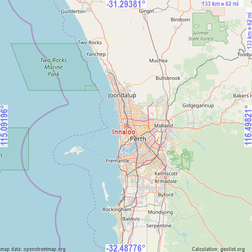
Innaloo GPS coordinates[2]
31° 53' 33.792" South, 115° 47' 42.288" East
| Map corner | latitude | longitude |
|---|---|---|
| Upper-left | -31.29381°, | 115.09196° |
| Center: | -31.89272°, | 115.79508° |
| Lower-right: | -32.48776°, | 116.49821° |
| Map W x H: | 132.8×132.8 km | = 82.5×82.5mi |
| max Lat: | -10.58257° ⇑33.1% North |
| Innaloo: | -31.89272° |
| min Lat: | ⇓66.9% South -43.31423° |
| min Long | Innaloo | max Long |
| 113.53327° | 115.79508° | 153.61246° |
| W 3.7%⇐ | ⇒96.3% E |
Elevation
Elevation of Innaloo is 8 m = 26 ft, and this is 114 m = 374 ft below average elevation for this country.
| Max E: |
1715 m = 5627 ft | 91.8% |
| Avg. | 122 m = 400 ft | |
| Innaloo | 8 m = 26 ft | |
Min E: |
-2 m = -7 ft | 8.2% |
See also: Australia elevation on elevation.city.
Geographical zone
Innaloo is located in South temperate zone (between Tropic of Capricorn and the Antarctic Circle). Distance of this Southern Tropic circle is 940.2 km =584.2 mi to North.| Distance of | km | miles | from Innaloo |
|---|---|---|---|
| Equator | 3546.1 | 2203.4 | to North |
| Tropic Capricorn | 940.2 | 584.2 | to North |
| Antarctic Circle | 3855 | 2395.4 | to South |
| South Pole | 6460.9 | 4014.6 | to South |


Nearby cities:
15 places around Innaloo: (largest is in red/bold)
• Balcatta
3.7 km =2.3 mi,  57°
57°
• Carine
4.6 km =2.9 mi,  345°
345°
• Churchlands
3.2 km =2 mi,  183°
183°
• Doubleview
1.3 km =0.8 mi,  252°
252°
• Glendalough
3.8 km =2.4 mi,  142°
142°
• Gwelup
2.3 km =1.4 mi,  359°
359°
• Joondanna
4.8 km =3 mi,  110°
110°
• Karrinyup
2.8 km =1.7 mi,  322°
322°
• Mount Hawthorn
4.8 km =3 mi,  128°
128°
• Osborne Park
1.7 km =1.1 mi,  120°
120°
• Scarborough
2.9 km =1.8 mi,  263°
263°
• Stirling
1.7 km =1.1 mi,  53°
53°
• Trigg
4.4 km =2.7 mi,  305°
305°
• Tuart Hill
3.8 km =2.4 mi,  98°
98°
• Wembley Downs
2.9 km =1.8 mi,  223°
223°
Sources, notices
• [Note1] Compared only with cities in Australia existing in our database
• [Src1] Map data: © OpenStreetMap contributors (CC-BY-SA)
• [Src2] Other city data from geonames.org with taken over terms of usage.
• [Src3] Geographical zone / Annual Mean Temperature by Robert A. Rohde @ Wikipedia
