Bonnyrigg geodata
Bonnyrigg (New South Wales) is a section of populated place; located in Australia in Australia/Sydney (GMT+10) time zone. With population of 8,697 people, there are 733 cities with bigger population in this country. Compared to other cities in Australia, 55.8% of cities are located further ↑North; 65.1% of cities are located further ←West and 54.5% of cities have lower elevation than Bonnyrigg. Note1


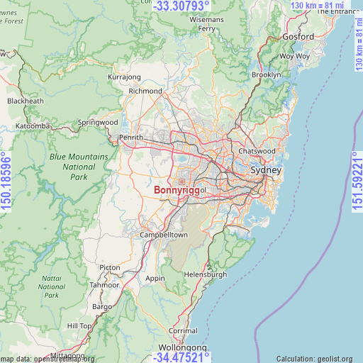
Bonnyrigg GPS coordinates[2]
33° 53' 36.852" South, 150° 53' 20.688" East
| Map corner | latitude | longitude |
|---|---|---|
| Upper-left | -33.30793°, | 150.18596° |
| Center: | -33.89357°, | 150.88908° |
| Lower-right: | -34.47521°, | 151.59221° |
| Map W x H: | 129.8×129.8 km | = 80.7×80.7mi |
| max Lat: | -10.58257° ⇑55.8% North |
| Bonnyrigg: | -33.89357° |
| min Lat: | ⇓44.2% South -43.31423° |
| min Long | Bonnyrigg | max Long |
| 113.53327° | 150.88908° | 153.61246° |
| W 65.1%⇐ | ⇒34.9% E |
Elevation
Elevation of Bonnyrigg is 52 m = 171 ft, and this is 70 m = 230 ft below average elevation for this country.
| Max E: |
1715 m = 5627 ft | 45.5% |
| Avg. | 122 m = 400 ft | |
| Bonnyrigg | 52 m = 171 ft | |
Min E: |
-2 m = -7 ft | 54.5% |
See also: Australia elevation on elevation.city.
Geographical zone
Bonnyrigg is located in South temperate zone (between Tropic of Capricorn and the Antarctic Circle). Distance of this Southern Tropic circle is 1162.7 km =722.5 mi to North.| Distance of | km | miles | from Bonnyrigg |
|---|---|---|---|
| Equator | 3768.6 | 2341.7 | to North |
| Tropic Capricorn | 1162.7 | 722.5 | to North |
| Antarctic Circle | 3632.6 | 2257.2 | to South |
| South Pole | 6238.5 | 3876.4 | to South |


Nearby cities:
15 places around Bonnyrigg: (largest is in red/bold)
• Ashcroft
2.7 km =1.7 mi,  158°
158°
• Bonnyrigg Heights
1.8 km =1.1 mi,  278°
278°
• Busby
2.1 km =1.3 mi,  201°
201°
• Cabramatta West
2.1 km =1.3 mi,  88°
88°
• Canley Heights
3.5 km =2.2 mi,  69°
69°
• Cartwright
3.5 km =2.2 mi,  179°
179°
• Edensor Park
1.9 km =1.2 mi,  325°
325°
• Green Valley
2.3 km =1.4 mi,  242°
242°
• Greenfield Park
2.1 km =1.3 mi,  7°
7°
• Heckenberg
1.6 km =1 mi, 177°
• Miller
3.1 km =1.9 mi,  187°
187°
• Mount Pritchard
1.8 km =1.1 mi,  125°
125°
• Sadleir
2.6 km =1.6 mi, 176°
• St Johns Park
1.7 km =1.1 mi,  44°
44°
• Wakeley
2.9 km =1.8 mi, 41°
Sources, notices
• [Note1] Compared only with cities in Australia existing in our database
• [Src1] Map data: © OpenStreetMap contributors (CC-BY-SA)
• [Src2] Other city data from geonames.org with taken over terms of usage.
• [Src3] Geographical zone / Annual Mean Temperature by Robert A. Rohde @ Wikipedia
